


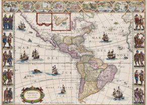
The Americas – Americae Sive Novi Orbis Nova Descriptio
Detail
Date of first edition: 1587
Date of this map: 1595
Dimensions (without margins): 35 x 48 cm
Dimensions with margins: 44 x 55 cm
Condition: Very good engraving on strong. Wide margins. Original colouring.
Condition rating: A+
Verso: text in Latin
Map reference: Van den Broecke, 11
From: Theatrum Orbis Terrarum
In stock
The Americas by Ortelius
This is the third plate that Ortelius used of the Americas. It is the most geographically advanced.
This is the third of three copper plates that Ortelius used to depict the American continent. Geographically it is the most advanced. This is the only one of the three plates which is signed by Ortelius as responsible for the preparation of the map.
The first, of 1570, had by now developed a number of cracks. It is almost identical to the earlier plate with the exception of the following:
1570 plate: The largest ship in the Pacific is sailing westwards, and the Equator is shown with no graduations between the longitudinal marks.
1579 plate: The largest ship in the Pacific is shown sailing eastwards, and there now appear graduations along the equatorial line.
1587 plate: The bulge to the south-western coast of South America (Chile) is removed.
Ortelius depicts the discoveries of several people on this map. The general shape of the continent is derived from Gerard Mercator’s great twenty-one sheet world map of the previous year. The two of them had a close relationship and shared their knowledge openly with each other. It is recorded that they traveled together through France in 1560. A strategically placed cartouche hides a complete lack of knowledge of the southern waters of the Pacific.The title is decorated with the key-like geometric decorations common to the maps in Ortelius’ atlas. In the ocean, a sea monster lurks. In the Pacific, ships stream through the water, their sails filled with imaginary winds.
The Straits of Magellan separate South America from a large southern continent that extends all the way to New Guinea. Tierra del Fuego, named by Magellan because he saw so many small fires burning there, is part of this continent. The name “Novae Guinea”, or New Guinea, was coined by Spanish explorer Íñigo Ortíz de Retes in 1545, and it refers to his opinion that the appearance of the native peoples resembled the natives of the Guinea region of Africa.
Once through the Strait of Magellan, the voyager’s sea route took him on an almost direct course for the East Indies. No sight had been made of a vast continent, but conventional wisdom had it that there had to be as much land in the southern hemisphere as in the northern. This was not entirely dispelled until the second voyage of the remarkable Captain James Cook in 1772-75. The west coast of North America is shown too far west, as was common at the time. C.Mendocino is added to the north west coast.
Two place names in the northwest of North America are particularly interesting. Anian derives from Ania, a Chinese province on a large gulf mentioned in Marco Polo’s travels (ch. 5, book 3). The gulf Polo described was actually the Gulf of Tonkin, but the province’s description was transposed from Vietnam to the northwest coast of North America. The first map to do was Giacomo Gastaldi’s world map of 1562, followed by Zaltieri and Mercator in 1567. The Strait then became shorthand for a passage to China, i.e. a Northwest Passage. It appeared on maps until the mid-eighteenth century.
Quivira refers to the Seven Cities of Gold sought by the Spanish explorer Francisco Vasquez de Coronado in 1541. In 1539, Coronado wandered over what today is Arizona and New Mexico, eventually heading to what is now Kansas to find the supposedly rich city of Quivira. Although he never found the cities or the gold, the name stuck on maps of southwest North America, wandering from east to west.
The Salomon Islands are inserted
There is no new nomenclature shown.
INFORMATION ADED BY JAMES WILLIAM ROY (as a reaction on my Facebook posting)
Related items
-
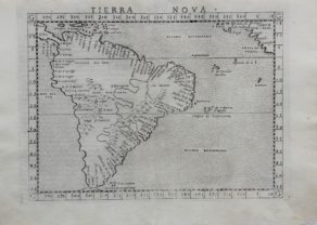
South America – Tierra Nova
by Girolamo RuscelliPrice (without VAT, possibly to be added): €650,00 / $721,50 / £578,50 -
The Americas – Americae nova tabulae
by Willem and Joan BlaeuPrice (without VAT, possibly to be added): €7 500,00 / $8 325,00 / £6 675,00The most beautiful map of the continent: the absolutely top unique carte-à-figures … in time and place
You may also be interested in:

Edinburgh

San Adrian (Navarre) – La Sierra de Sant Adrian en Biscaia

Map of the Moon – Tabula Selenographica in qua Lunarium
The unique and famous first comparative chart of the Moon (with double competing nomenclature) from which the names of many lunar features have been derived.
