


South America – Tierra Nova
by
Girolamo Ruscelli
Detail
Date of first edition: 1561
Date of this map: 1561
Dimensions (not including margins): 18,2 x 24,5 cm
Dimensions (including margins): 22,5 x 31,8 cm
Condition: Very good.
Condition rating: A
Verso: blank
From: La Geografia di Claudio Tolomeo
Price (without VAT, possibly to be added): €650,00 (FYI +/- $721,50 / £578,50)
Unless otherwise specifically stated on this map page, we charge the following expedition costs in euro (unfortunatelly, gone up with Covid, but still too low in reality!):
– Benelux: 40 euro
– Rest of Europe: 60 euro
– Rest of the World: 100 euro
In stock
Related items
-
Brasil Nuova Tavola
by Girolamo RuscelliPrice (without VAT, possibly to be added): €650,00 / $721,50 / £578,50First edition of first map of Brasil
-
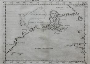
Northeastern Coast of America – Tierra Nueva
by Girolamo RuscelliPrice (without VAT, possibly to be added): €1 900,00 / $2 109,00 / £1 691,00History on paper
You may also be interested in:

China, Tartary and Japan
by
Lorenz Fries (after Martin Waldseemüller)
Price (without VAT, possibly to be added): €4 000,00 / $4 440,00 / £3 560,00
The first modern map of China printed in Europe

[Untitled] Japan
by
Benedetto Bordone
Price (without VAT, possibly to be added): €2 800,00 / $3 108,00 / £2 492,00
Very rare: oldest map of Japan, and … based on Polo’s description

Cuzco (Inca capital)
by
Giovanni Battista Ramusio
Price (without VAT, possibly to be added): €850,00 / $943,50 / £756,50
Rare first edition (block destroyed by fire)

Achaia, Attica and Gulf of Corinth
by
Johannes Janssonius
Price (without VAT, possibly to be added): €450,00 / $499,50 / £400,50
Uncommon first edition
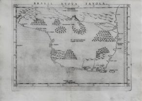
The towns at the coast are drawn in such a way that they form the desired coastline.
Only a few Inca cities in Peru Provincia including Cusco and Caxamalca mentioned. The Amazon meanders like a snake down, but does not come into contact with the water system of Plata.
Top right one can notice a tip West Africa and bottom is named Strecho the Magellanes.
Ruscelli shows many islands in the Atlantic. For example Y. Fernando Lorena (now Fernando de Noronha), an archipelago of 21 islands, which were discovered during an expedition in 1503 (sponsored by the Lisbon merchant of Lisbon Fernão the Loronha). Amerigo Vespucci was part of this expedition. Between 1503 and 1512 the consortium of Loronha held a trade monopoly on Brazil. This group was particularly interested in the barzilwood (Caesalpinia echinata). The name of the larger area which was first called Santa Cruz and Veracruz, had already been replaced by Terra do Brasil.
Ruscelli
Girolamo Ruscelli (1504 Viterbo -1566 Venice), an Italian Alchemist, Physician and cartographer, was editor of a revised and expanded Italian edition of Ptolemy’s ‘Geographia’, published as ‘La Geografia di Claudio Tolomeo. The newly engraved maps were based, generally, on those compiled by Giacomo Gastaldi for the Venice miniature atlas edition of 1548.
Ruscelli’s atlas was issued several times between 1561 and 1599 by the following publishers
– Venice, Vincenzo Valgrisi, 1561
– Venice, Vincenzo Valgrisi, 1562
– Venice, G. Zileti, 1564
– Venice, G. Zileti, 1574
– Venice, Heirs of Melchior Sessa, 1598-99
The Ruscelli and Gastaldi atlases were the most comprehensive atlases produced between Martin Waldseemüller’s ‘Geographia’ of 1513, and Abraham Ortelius ‘Theatrum’ of 1570. The significance of the Gastaldi and Ruscelli atlases cannot be overestimated. They defined the known geography of the world for decades. These atlases also reintroduced the use of copper engraving into the service of cartography, which was dominated by woodcut printing after several not very succesful attempts to print from copper in the 15th century. The Gastaldi and Ruscelli atlases proved that maps could be beautifully engraved on copper. As it was a harder material than wood, it was harder to engrave but also gave the ability to render much more detail. The Gastaldi and Ruscelli atlases marked a turning point in the history of cartography, from then on the majority of cartographic works used this medium.
“Ruscelli was editor of a revised and expanded edition of Ptolemy’s Geographia which was issued in Venice several times between 1561 and the end of the century.
The newly angraved maps were based, generally, on those compiled by Giacomo Gastaldi for the Venice edition of 1548.”
(Moreland & Bannister).
Off the African coast of Africa Ruscelli portrays some islands of the Cape Verde archipelago from which four are named: (San) Tiago, Lucia, Sal and Mayo.
The map is based upon a 1548 map of the same title published in Giacomo Gastaldi’s La Geografia. One of the earliest obtainable maps of South America. The map was first issued in 1561. The plate was revised in 1574 and again in 1598. The 1598 rework can be distinguished by the inclusion of a sailing ship in the lower right corner.