
New England – Nouvelle Hollande … Nouvelle Angleterre
by
Pieter van der Aa, Arnold Montanus
Exceptional beauty
Detail
Date of first edition: 1671 (Arnoldus Montanus)
Date of this map: 1725 (Pieter van der AA; first edition 1713)
Dimensions (not including margins): 30 x 37 cm
Condition: Very good with beautiful and vivid cartouche. Strong paper and very wide margins .
Condition rating: A+
Verso: blanc
Price (without VAT, possibly to be added): €1 900,00 (FYI +/- $2 109,00 / £1 691,00)
Unless otherwise specifically stated on this map page, we charge the following expedition costs in euro (unfortunatelly, gone up with Covid, but still too low in reality!):
– Benelux: 40 euro
– Rest of Europe: 60 euro
– Rest of the World: 100 euro
In stock
Related items
You may also be interested in:

Luxembourg, Duchy
by
Abraham Ortelius
Price (without VAT, possibly to be added): €750,00 / $832,50 / £667,50

Avignon
by
Georg Braun and Frans Hogenberg
Papal city²

Chart of the Gulf of Finland
by
Lucas Janszoon Waghenaer

Algiers – Algerii Saracenaorum Urbis Fortissimae…
by
Georg Braun and Frans Hogenberg
Price (without VAT, possibly to be added): €800,00 / $888,00 / £712,00
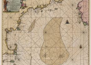
From Montanus 1671 to van der Aa 1725
Van der Aa, a publisher of several early 18th-century atlases, based his 1713 map of New York and New England on a 1671 map by Arnoldus Montanus. The title cartouche was removed along with the scale of miles and decorative animals, and then a new title was added with a colonial scene depicting Native Americans assisting the Europeans in clearing the land and exploiting its natural resources. As part of the cartographic progression of maps of the Northeast initiated by Johannes Janssonius and Nicolas Visscher in the 1650s, this map is the only one of the thirty-map series to show Providence and to name Canada. There are new and important place names in Canada, along the Connecticut and Delaware Rivers, and around the Chesapeake Bay.
The map is full of Indian names, but many familiar colonial names sound quite familiar: