


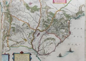
Bay of All Saints – Bahia de Todos los Sanctos
by
Joan Blaeu
Detail
Date of first edition: 1662
Date of this map: 1663
Dimensions (not including margins): 39 x 50,5 cm
Dimensions (including margins): 50,5 x 59 cm
Condition: excellent. Sharp copper engraving printed on strong paper. Old colouring. Some age-toning. Wide margins.
Condition rating: A+
Verso: text in French
Map reference: Van der Krogt II, 9855:2-2
From: Le Grand Atlas (Atlas Maior). Van der Krogt II, 2:611, page 257-258
Price (without VAT, possibly to be added): €625,00 (FYI +/- $693,75 / £556,25)
Unless otherwise specifically stated on this map page, we charge the following expedition costs in euro (unfortunatelly, gone up with Covid, but still too low in reality!):
– Benelux: 40 euro
– Rest of Europe: 60 euro
– Rest of the World: 100 euro
In stock
Related items
You may also be interested in:

Lucca
by
Georg Braun and Frans Hogenberg
Price (without VAT, possibly to be added): €700,00 / $777,00 / £623,00

Toledo (Castile) – Toletum
by
Georg Braun and Frans Hogenberg
Price (without VAT, possibly to be added): €1 500,00 / $1 665,00 / £1 335,00

Scotland – Nova Scotia
by
Willem and Joan Blaeu
Price (without VAT, possibly to be added): €1 000,00 / $1 110,00 / £890,00
A nice map of Scotland

Avignon
by
Georg Braun and Frans Hogenberg
Papal city²
Bay with a name
The Bay of All Saints (Portuguese: Baía de Todos os Santos), also known as All Saints’ Bay and Todos os Santos Bay, is the principal bay of the Brazilian state of Bahia, to which it gave its name.
The Italian explorer Amerigo Vespucci was the first European to visit the bay, during his second expedition to the Americas. He entered the bay on All Saints’ Day (November 1), 1501. He named the Bay of the Holy Savior of All the Saints after the date and his parish church in Florence, San Salvatore di Ognissanti. Initially, the bay, its principal settlement, and the captaincy around it all shared the same name, but they were eventually distinguished, the state becoming simply Bahia, the bay becoming the Bay of All Saints, and the city becoming first Bahia and now (usually) Salvador
Orientation: NNE
Latin key A-S
Title added: Sinus Omnium Sanctori