


Novae Hispaniae, Chili, Peruviae, et Guatimalae
Rare and beautiful
Detail
Date of first edition: ca. 1675
Date of this map: 1745
Dimensions (not including margins): 48,5 x 56,5 cm
Dimensions (including margins): 55,5 x 65,2
Condition: Very good. Strong paper. Wide margins. Centre fold as published. Nice colouring. Tape along paper borders at verso, not affecting the recto and/or map.
Condition rating: A+
Verso: blank
In stock
De Wit – Ottens
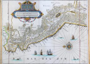
Rare sea chart from De Wit’s Orbis Maritimus ofte Zee Atlas. Covers the Pacific Coast from Xalisco, Mexico to Puerta Bairres and Rio Cachapool in Chile, covering over two thirds of the Chilean Coast. In the Caribbean, all of the Yucatan and parts of Cuba and Hispaniola are shown, along with all of Jamaica and the Caymans. Nice detail throughout Central America. Columbia is shown in its entirety, along with a small piece of Venezuela. Includes well over 100 place names in classic Portolano style, along with gorgeous allegorical cartouche, 8 sailing ships and two compass roses, in full original color. T
The first edition of this marvelous sea chart, later copied in the 18th Century by Renard (1715) and Ottens (1745). This copy is from Ottens.
Related items
You may also be interested in:

[Untitled] Japan
Very rare: oldest map of Japan, and … based on Polo’s description

Algiers – Algerii Saracenaorum Urbis Fortissimae…

Michiel de Ruyter, a super collection by Stoopendaal
Maybe the greatest admiral of all times

Avignon
Papal city²