


Holy Land – Situs Terrae Promissionis SS Bibliorum Intelligentiam Exacte Aperiens
by
Christiaan van Adrichem
The most beautiful map of the Holy Land
Detail
Date of first edition: 1590
Date of this edition: 1590
Dimensions (not including margins): 100,2 x 35,4 cm
Dimensions (including margins): 102,3 x 39,5 cm
Condition: Very good. Sharp copper engraving printed on paper on two sheets. Old coloured. Large map with wide margins (top and bottom) and slim margins (left and right). A few minor professional repairs in margins.
Condition rating: A
Map reference: Nebenzahl p. 94
From: Thearum Terrae Sanctae. Keulen, Officina Birckmannica
Price (without VAT, possibly to be added): €3 800,00 (FYI +/- $4 218,00 / £3 382,00)
Unless otherwise specifically stated on this map page, we charge the following expedition costs in euro (unfortunatelly, gone up with Covid, but still too low in reality!):
– Benelux: 40 euro
– Rest of Europe: 60 euro
– Rest of the World: 100 euro
In stock
Related items
You may also be interested in:

Cuzco (Inca capital)
by
Giovanni Battista Ramusio
Price (without VAT, possibly to be added): €850,00 / $943,50 / £756,50
Rare first edition (block destroyed by fire)

Achaia, Attica and Gulf of Corinth
by
Johannes Janssonius
Price (without VAT, possibly to be added): €450,00 / $499,50 / £400,50

Veere – Vere
by
Ludovico Guicciardini
Price (without VAT, possibly to be added): €420,00 / $466,20 / £373,80

Asia Secunda pars Terrae in Forma Pegasi
by
Heinrich Bünting
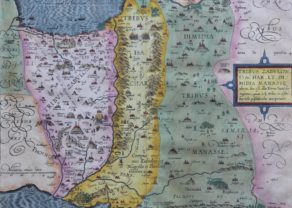
van Adrichem: the entire Bible in one superb map
This double folio map actually summarizes nine smaller ones of the tribes of Israel and one representing Moses’ exodus. It shows the entire region between Sidon (in the North; left) and Alexandria in Egypt. One recognizes locations as identified in the Old and New Testaments, all jumbled up. The colors indicate more or less the separate positions of the 12 tribes of Israel.
The 12 sons of the patriarch Jacob were in order of age Reuben, Simeon, Levi, Judah, Dan, Naphtali, Gad, Asher, Issachar, Zebulun, Joseph and Benjamin. Each of them became forefather to an area/tribe, with the exception of Joseph and Levi. Instead of Joseph, his two sons Ephraim and Manasseh received a region. Lefi, the 12th son was not designated a territory, but his descendants had to take care of the sanctuary. This family history explains the structure of the work and the presence of the smaller maps.
Prominent in the East flows river Jordan, as crucial as it was then and now, into the Dead Sea. There, God has set fire to Sodom and Gomorrah (Book Genesis, verse 18 and 19). North of Sidon, Saint George slays the dragon. Jerusalem dominates the center. In the South the Red Sea opens up enabling Moses to undertake his 40 years journey towards the Promised Land. The tribes take a rest during their zigzag wandering through the desert: see the Tabernacle. Absent on all old maps is the Gulf of Aqaba. Finally and according to anachronistic use, 16th century ships bobble on the sea. From one of them the Prophet Jonas is thrown overboard and swallowed by a whale… just for three days!
Some classic cartographic errors are not missing: The Nile delta lies in the extension of the coast of the Holy Land. Cities such as Alexandria, Heliopolis, Memphis and Thebes, plus a few pyramids are correctly illustrated. Or another typical mistake: a river connecting the Lake of Galilee with the Mediterranean Sea.
Christiaan van Adrichem was born in Delft in 1533, studied many years in Leuven, but he finally settled in Köln, where he died in 1585. His key work, the Theatrum Terra Sanctae et Biblicarum Historiam, was postmortem published by Frans Hogenberg in 1590. It is in fact an historical study of the geographical locations as mentioned in the Old and New Testament; therein described in a sort bullet point listing; hence all the numbers on the maps. His main cartographic sources are the maps of “Ptolemy” (1513), Ziegler (1532) and Laicksteen (1570) and, further, Burckhard of Mount Sion and Sanuto.