
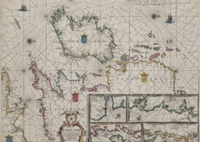
Ancient British Isles – Britannicarum Insularum Typus
by
Abraham Ortelius
Detail
Date of first edition: 1595
Date of this map: 1595-1612
Dimensions (not including margins): 36,5 x 50,5 cm
Condition: excellent. Sharp copper engraving printed on strong paper. Centre fold is as published. Old coloured. Wide margins.
Condition rating: A+
Map reference: Van den Broecke 192. Van der Krogt 5000H:31B
From: Theatrum Orbis Terrarum
Price (without VAT, possibly to be added): €900,00 (FYI +/- $999,00 / £801,00)
Unless otherwise specifically stated on this map page, we charge the following expedition costs in euro (unfortunatelly, gone up with Covid, but still too low in reality!):
– Benelux: 40 euro
– Rest of Europe: 60 euro
– Rest of the World: 100 euro
In stock
Related items
You may also be interested in:

[Untitled] Japan
by
Benedetto Bordone
Price (without VAT, possibly to be added): €2 800,00 / $3 108,00 / £2 492,00
Very rare: oldest map of Japan, and … based on Polo’s description

Map of the Moon – Tabula Selenographica in qua Lunarium
by
Johann Gabriel Doppelmayr
Price (without VAT, possibly to be added): €3 500,00 / $3 885,00 / £3 115,00
The unique and famous first comparative chart of the Moon (with double competing nomenclature) from which the names of many lunar features have been derived.

Scotland – Nova Scotia
by
Willem and Joan Blaeu
Price (without VAT, possibly to be added): €1 000,00 / $1 110,00 / £890,00
A nice map of Scotland

Chester – Cestria vulgo Chester, Angliae Civitas
by
Georg Braun and Frans Hogenberg
Price (without VAT, possibly to be added): €900,00 / $999,00 / £801,00
Britannica by Ortelius
Engraved by Jan Wierix. Bertius bought a number of sheets with this map en included the map in his historical 1619 atlas Theatrum Geographicae Veteris. Shirley also reports (p. 105) a copy from a mysterious 1603 edition with Italian text.
Note the elaborate ship just left of the cartouche. It represents state-of-the-art shipbuilding, not of Greek or Roman antiquity, but of the Low Countries towards the end of the end of the 16th century. Such anachronistic illustrations were common in historic cartography.
Also note both the Hadrian (built ca. 122; declared a UNESCO World Heritage in 1987)) and the Antonine walls.