Menu
SCOTIA REGNUM, QUO VADIS (what’s your future)?
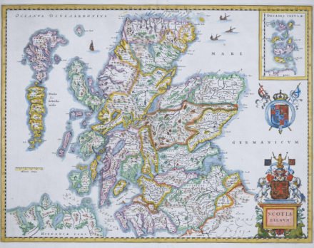
The Kingdom of Scotland emerged as an independent sovereign state in the Early Middle Ages and continued to exist for several centuries until 1707. By inheritance in 1603, James VI, King of Scots, became King of England and King of Ireland, thus forming a personal union of the three kingdoms. On 1 May 1707 Scotland entered into a political union with the Kingdom of England to create the new Kingdom of Great Britain. As a consequence, the Parliament of Scotland merged with the Parliament of England to form the Parliament of Great Britain which sat a Westminster in London.
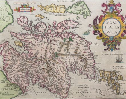
This map is essentially an enlarged part of the British Isles map, (vdB 16). Next to the Orcades insulaethe isles of Orkney have been added. Cardenbrog has been changed to Carndeburg and Northeast of the Hebrides the isle of Roma has been added.
Scotland is home to almost 800 small islands, including the northern isles of Shetland (not on the map) and Orkney (see inset), the Hebrides, Arran (yellow below) and the long Skye (green). In green (left bottom) one recognizes the northern coastline of Ireland. Loch Ness prominently features as the long (somewhat too broad lake in the top middle of the map). This is a very attractive copy of Blaeu’s first map of the Kingdom, based on Mercator’s of 1595. Although first published in 1634, this example, lacking text on the reverse was probably issued around 1660.
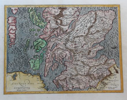
This is the southern sheet of Hondius’ two separate sheets map of Scotland, which extends from the southern end of the Isle of Sky and the Hebrides down to the border of England. The map names Glasgow (Glasquo) and Edinburgh (Edyunburgh) and is filled with rivers, rugged mountains and many place names. Loch Ness is clearly indicated and left bottom lies Ireland. The Hebrides Islands are superbly delineated. Distances are in Scottish miles.
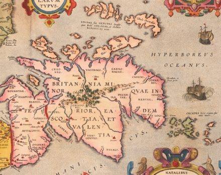
Ortelius published a superb map of the British Isles in the Antiquity. Engraved by Jan Wierix. Bertius bought a number of sheets with this map and included the map in his historical 1619 atlas Theatrum Geographicae Veteris. Shirley reports (p. 105) a copy from a mysterious 1603 edition with Italian text.
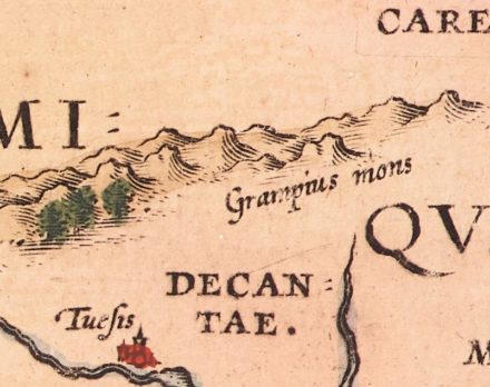
The Battle of Graupius was, according to Tacitus, a Roman military victory, probably taking place in 83 AD.
Both Roman walls are clearly visible: the Antonine Wall (constructed 142 AD) runs more or less from Glasgow to Edinburgh. Hadrian’s Wall (constructed 122 AD; declared a UNESCO World Heritage in 1987) runs in the West from famous Scottish Gretna Green (in the West; and still border town. Note the elaborate ship just left of the cartouche. It represents state-of-the-art shipbuilding, not of Greek or Roman antiquity, but of the Low Countries towards the end of the end of the 16th century. Such anachronistic illustrations were common in historic cartography.
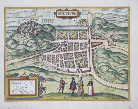
On the Braun-Hogenberg city map Edinburgh Castle, indicated as Castrum puellarum, or “Maidens’ Castle” dominates the view. According to one legend the origins of the designation can be traced back to a tradition among the Picts of holding virgins captive in the castle. Other sources refer to a legend claiming that princesses were able to live there in safety. It is also the place where King Malcolm III’s widow, later St Margaret of Scotland, allegedly resided in the 11th century. The upper and large, horizontal thoroughfare, the High Street (later called the Royal Mile, due to its distance), runs from the Castle Rock via the Gothic church of St Giles to the town gate in the east to Holyrood abbey (now in ruins). The guesthouse of the abbey was later transformed into the official residence of the British Monarchy in Scotland, the Palace of Holyroodhouse. Around 1550 the town had 15.000 inhabitants; today some 490.000 people live in Scotland’s capital.
***
On 18 September 2014 a referendum on Scottish Independence from the United Kingdom took place in which 55.3% voted in favor of the union. Then, only Greater Glasgow and Dundee voted in majority for independence. In the 2016 EU referendum all of the 32 constituencies of Scotland voted Remain, with an overall favorable vote of 68%.
So Scotland, a true European nation, quo vadis?