


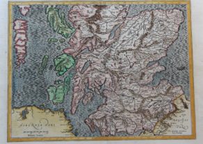
Scotland – Scotiae Tabula
Superb standard setting map of Scotland by Ortelius
Detail
Date of first edition: 1573
Date of this map: 1598
Dimensions (not including margins): 47 x 58,8 cm
Dimensions (including margins): 35,8 x 47,8 cm
Condition: Excellent. Sharp engraving on strong paper. Centre fold as published. Attractive discrete hand coloring. Wide margins. An old manuscript page number (11) was added in the bottom blank margin.
Condition rating: A+
Verso: text in French
Map reference: Van der Krogt IIIB, 5800:31 van den Broecke 18
From: Théatre de l’Univers (Theatrum Orbis Terrarum), Van der Krogt IIIB, 31:351 verso mention ’11’. Mention last line: ‘soubs les Roys de Danemarc…’. Printed at Plantin Press, Antwerp.
In stock
Van den Broecke remarks:
This map is essentially an enlarged part of the British Isles map, (vdB 16). Next to the Orcades insulaethe isles of Orkney have been added. Cardenbrog has been changed to Carndeburg and Northeast of the Hebrides the isle of Roma has been added.
Related items
-

Scotland – Nova Scotia
by Willem and Joan BlaeuPrice (without VAT, possibly to be added): €1 000,00 / $1 110,00 / £890,00A nice map of Scotland
-
South Scotland – Scotiae parts septentrionalis
by Gerard Mercator, Jodocus Hondius Jr.Price (without VAT, possibly to be added): €500,00 / $555,00 / £445,00Per Gerardum Mercatorem
Cum privilegio
-

Edinburgh
by Georg Braun and Frans HogenbergPrice (without VAT, possibly to be added): €1 700,00 / $1 887,00 / £1 513,00
You may also be interested in:

Jan Mayen – Insulae Johannis Mayen Cum universe situ Sinuum et Promontariorum
Rare Spanish edition

Cuzco (Inca capital)
Rare first edition (block destroyed by fire)

Bristol – Brightstowe, Vulgo; Quondam Venta, Florentissimum

Avignon
Papal city²