Menu
Strait of Magellan & Cape Horn: the Dutch experience
Date: 25/11/2020
This blog focusses on the three most important Dutch maps of the Strait of Magellan and Cape Horn. They provide ample information on several the Dutch passages.
1. Before the Dutch
First, let’s go back in time: After it became clear that a direct westerly voyage was out of the question (as Columbus encountered the American continent) and when the Treaty of Tordesillas in 1494 also made east voyages impossible for the Spanish, Spain had to look for an alternative to its quest in the west for (gold and) spices. It became the southwestern route. The Strait of Magellan is located on the extreme south coast of the American continent and separates the continent and the island of Tierra del Fuego. The Strait is about 600 km long. It was first crossed under Magellan in 1520. The term “Magellanica” came into use, referring to the land on the south bank of the Strait (to begin with Tierra del Fuego) and all further (unknown) connected land. Magellanica is in fact a synonym for the mythical Southland or the Terra Australis incognito.
After him many others followed:
- 1526 García Jofre de Loaísa passed through the Strait in 122 days.
- 1540 Francisco de la Ribera: one ship from his fleet sailed down the Strait.
- 1559 Juan Fernández Ladrillero was the first to cross the Strait in both directions.
- 1578 Francis Drake sailed down the Strait in 16 days (second world circumnavigation).
- 1584 Pedro Sarmiento de Gamboa sailed through the Strait from west to east in 34 days.
- 1587 Thomas Cavendish sailed the Strait in 49 days (third world circumnavigation).
- 1594 Richard Hawkins sailed the Strait in 46 days.
And then, the Dutch came:
- 1599 Simon de Cordes from Jacques Mahu’s (Dutch) fleet sailed through the Strait in four months.
- 1600 Olivier van Noort was the first Dutchman to sail around the world (fourth world circumnavigation). He passed the Strait in 116 days.
- 1614 Joris van Spilbergen was the second Dutchman to sail through the Strait in 34 days (during the fifth world circumnavigation).
- 1615 Le Maire and Schouten: after their passage, taken prisoner by the VOC authorities in Batavia.
This study discusses the most recent explorations laid down in the three world-famous Dutch maps of the region:
- The Heijns – Hondius map (originally published 1606/this map 1630)
- The Janssonius – Hondius map (1630/1633)
- The Blaeu map (1635/1644-1655)
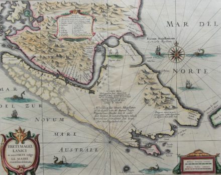
2. The Heijns – Hondius map (originally published 1606/this map 1630)
The crossing of the Strait under Simon de Cordes in 1598 was undertaken with five ships and a crew of five hundred men. (This expedition was destined for the East Indies, but it was unsuccessful to reach its destination). Remarkable to note that the expedition left from Rotterdam! At its start the commander was Jacques Mahu, but he died before the coast of Africa.
It was not unusual that large expeditions took an entire ship, in parts, with them. Indeed: this map shows six ships, including the small “reserve vessel”, the Postillon.
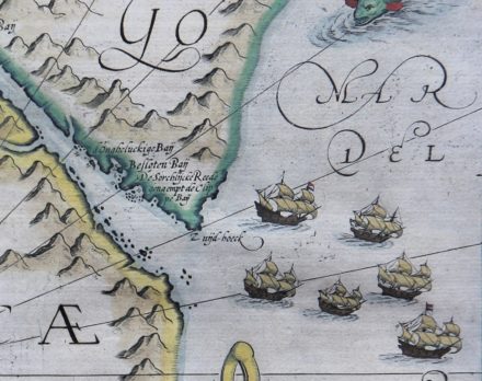
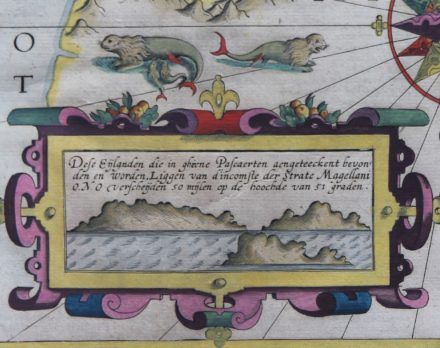
Nevertheless, this expedition can credit the “discovery” of the Sebaldinas (after Sebald de Weert), later called the Jason Islands (which is a sub-archipelago of the Falkland Islands). See below inset at bottom left of map.
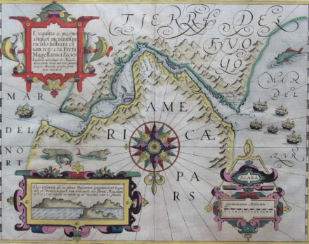
Outgersz drew this map, Lambertus Cornelij engraved it and Zacharias Heijns published it in 1600. From 1606 it would be published by Jodocus Hondius in a second state, among other things with the omission of the names Cornelij and Heijns. The south is at the top, so the Atlantic Ocean is on the left. Among other things, the following places are noted:
- Penguin Elk: today’s Magdalen Islands, still populated by a huge colony of Magellanic penguins;
- Capo Forward, now Cabo Froward, now adopted as the southernmost point on the rural continent;
- Cordes Baij, where 115 men starved to death;
- Ridder Baij, where a fraternity was founded.
Under Olivier van Noort, the Dutch undertook their first world tour between 1598 and 1601. His travelogue, the Beschrijvinghe vande voyagie om de geheelen wereldt Cloot gedaan door Olivier van Noort, will be published in the year of arrival. From his voyage, the unknown Capo d’Hollande (just west of the more famous Capo Froward, in fact the southernmost point of the continental mainland) has been immortalized. Baptista Doetecum engraved another map Fretum Magallanicum based on his data.
On this map North is bottom of the map. Tierra del Fuego, the green section at the top was not yet rounded when this map was drawn. Which means that also Cape Horn is missing.
3. The Janssonius – Hondius map (1630/1633)
From 1630, the house of Hondius published a new map of the Strait, containing new data. The map is indebted to the journey of Jacob le Maire and Willem Cornelisz Schouten. Jacob’s father, Isaac, had founded the Austraelsche Compagnie since he believed in an enormous Southland. The company would exploit and enjoy the exclusive trade for these southern regions. In the middle of the Strait Hondius “Portofamine”
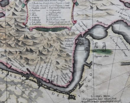
This relates to the Spanish an attempted settlement of “Rey don Felipe” with three hundred men in March 1584 under Pedro Sarmiento de Gamboa to block access to the strait to other nations, especially England (because Drake had passes the Strait in 1578). When the third world circumnavigation with Thomas Cavendish passed in 1587, it turned out that all Spanish settlers had died. Cavendish renamed the place Port Famine, which was later translated into Spanish as Puerto Hambre or Puerto del Hambre. On the empty space of Tierra del Fuego, Janssonius mentions that the image of the Strait of Magellan is based on information from Barent Iansz Potgieter from Munster. Let’s go back to Jacob le Maire and his contributions, which can be admired directly on the map. So, we notice:
- The Fretum le Maire of course immortalized its name. He proved that at least Tierra del Fuego was not part of the Terra Australis, the unknown Southland. He also discovered the “Staten Lant” (in the extreme right of the map). It was thought that this piece of land was part of Terra Australis. The answer came in 1643 when the expedition under Hendrick de Brouwer sailed round this tiny Isla de los Estados and so proved that it was not part of the (Imaginary) Terra Australis.
- C. de Horen, named after one of his two ships. The island of Cape Horn was then considered the southernmost point of South America.
- The islands of Terhalten, Ewoudt and Barnevelt are still called that way.
- The bays Greyhond (still known as Bahia Greyhond) and Schapenham in the Nassausche Voerd.
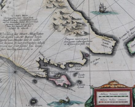
The discovery of the passage under the Tierra del Fuego (with current day well-known as the settlement of Ushuaia) was a major maritime breakthrough that ensured faster and safer passage between the two oceans. In the very south of the map are the I. De Diego Ramires. These islands were first spotted on February 12, 1619, during Garcia de Nodal’s expedition, and named after the expedition’s “cosmographer”, Diego Ramírez de Arellano . King Filip II of Spain had called for this expedition in order to verify the discoveries of Le Maire and Schouten. At this moment they are home to the most southern (Chilean) inhabited American point, as the Argentines had to leave the more southern Thule in 1982 (in the aftermath of the Falkland war). In 1624 the so-called Nassausche fleet passed through under the command of Jacques l’Hermite. His ship journalist, Johannes van Walbeeck, will include some places on the south coast of Tierra del Fuego, which are shown on this map.
4. The Blaeu map (1635/1644-1655)
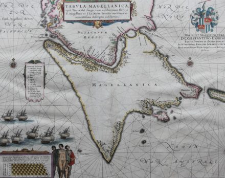
Willem Blaeu published a first version of this map in the Atlas Novus from 1635 onwards. This copy dates from 1644-1655 and comes from the atlas updated by son Joan. The general design of Tierra del Fuego and its adjacent islands actually comes into its own better in Hondius’s map. The position of the archipelago depicted as Lheremitens eylandt (now Isla Hermite) just north of Cape Horn (also an island) is equally suitable for Hondius. Blaeu also erroneously makes Cape Horn the southernmost point of Tierra del Fuego. However, the later mapmakers rather followed his map and not Hondius’s. Both Hondius and Blaeu rightly show the suggestion of a strait in the west of Tierra del Fuego. This is the so-called Beagle Canal, a street that was only discovered in 1830 during Charles Darwin’s cruise. This channel currently forms part of the border between Chile and Argentina on Tierra del Fuego. After many years of conflict the islands (Lennox, Picton and Nueva) at the opening of the Beagle Channel were awarded to Chile in 1984.
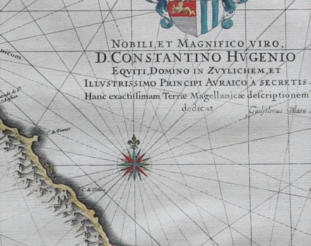
The cartouche at the top right mentions a dedication to Constantijn Huygens (The Hague, September 4, 1596 – The Hague, March 28, 1687), one of the greatest Dutch poets, and also a diplomat and composer. His coat of arms as lord of Zuilichem (a village east of Gorinchem in Gelderland) is displayed at the top. The English lions show that he received the knighthood from King James I in 1622 (where he was serving as a diplomat that year).
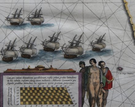
The naked man in the middle gave rise to Puritan protest. Blaeu then decided in later editions to provide the man with a skirt – without changing the copper plate itself. Blaeu continued to publish this map unaltered until 1670.
5. Why Cape Horn? Tribute to a city
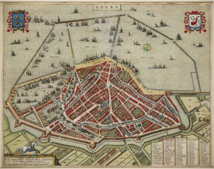
Hoorn was the main city of West Friesland which was annexed in 1297 by and to the county of Holland. In the sixteenth and seventeenth centuries, the city experienced its greatest boom. Hoorn had one representative in the Heeren XVII, the central administration of the VOC. The city was also represented in the WIC (West Indian Company) and the Northern Company (or Company of Spitsbergen). The Admiralty of the ‘Northern Quarter’ (north of the IJ) was also established in Hoorn. Thanks to Jacob Le Maire and Willem Scheuten the city name has obtained eternal fame when they rounded the Cape (Horn) in 1616.
Three reasons are now given for the naming:
- Schouten, the captain of the main ship’s expedition, was born in the city of Hoorn.
- The second and smaller ship was also called the Hoorn. The larger vessel was called De Eendraght (meaning Harmorny or Unity), referring to the unity of the young republic.
Their journey would also have been prepared in the city of Hoorn.
Schouten named the Cape on January 29, 1616, when he rounded the Cape together with Jacob le Maire. It says literally in the ship’s journal: twelck onse president ter eeren des stadts van Hoorn noemde Capo Hoorn (which our president called Capo Hoorn in honor of the city of Hoorn).
Collective purchase: an eccentric proposal
We now sell this special set of three Magellanica maps at the unedited discount price of 3.350 euro (transport costs and possible VAT excluded).