


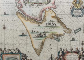
Strait of Magellan – Magellanica C
Magellanica, the Dutch experience
Detail
Date of first edition: 1606 (Jodocus Hondius in Atlas Gerardi Mercatoris…)
Date of this map: 1630 (Henricus Hondius in Atlas Gerardi Mercatoris…)
Dimensions copper plate (without margins): 35,2 x 46,2 cm
Dimensions (including margins): 40 x 53,6 cm
Condition: Very good. Copper print on strong paper with wide margins. Original colouring. General age-toning.
Condition rating: A
Verso: text in Latin
Map reference: Van der Krogt I, 9950:1.2
From: Atlas Gerardi Mercatoris Atlas sive Cosmographicae Meditationes de Fabrica Mundi et Fabrica Figura; Van der Krogt I, 1:107, page 390
This item is sold
Magellanica with Z. Heijns & H. Hondius
The Dutch experience
The crossing of the Strait under Simon de Cordes in 1599 was undertaken with five ships and a crew of five hundred men, destined for the East Indies, but was unsuccessful. The remaining ships returned. Nevertheless, this expedition can credit the “discovery” of the Sebaldinas (after Sebald de Weert), later called the Jason Islands (a sub-archipelago of the Falkland Islands) (see inset at bottom left of map). Outgersz drew this map, Lambertus Cornelij engraved it and Zacharias Heijns published it in 1600. From 1606 it would be published by Jodocus Hondius in a second state, among other things with the omission of the names Cornelij and Heijns. The south is at the top, so the Atlantic Ocean is on the left. Among other things, the following places are noted:
- Penguin Elk: today’s Magdalen Islands, still populated by a huge colony of Magellanic penguins;
- Capo Forward, now Cabo Froward, now adopted as the southernmost point on the rural continent;
- Cordes Baij, where 115 men starved to death;
- Ridder Baij, where a fraternity was founded.
Under Olivier van Noort, the Dutch undertook their first world tour between 1598 and 1601. His travelogue, the Description of the Voyagie around the whole world Cloot ghedaen by Olivier van Noort, will be published in the year of arrival. From his voyage, the unknown Capo d’Hollande (just west of the more famous Capo Froward, in fact the southernmost point of the continental mainland) has been immortalized. Baptista Doetecum engraved another map Fretum Magallanicum based on his data.
Related items
You may also be interested in:

Edinburgh

Lisbon

Portrait Abraham Ortelius, by Galle

Scotland – Nova Scotia
A nice map of Scotland
Collective purchase: an eccentric proposal
Have a look at our blog page. (just click here).
We have placed a lengthy and detailed historical and geographical study on the three main (Dutch) maps of the Strait of Magellan and Cape Horn. Here we mingle history and geography, continuing to the present! You find them under the name Strait of Magellan – Magellanica A, B and C.
A unique offer: We now sell this special set of four maps (A to D) at the discount price of 4.500 euro (transport costs and possible VAT excluded).