
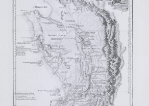
Chart of Cape of Good Hope
by
Johannes II van Keulen, Robert Laurie & James Wittle
Superb and rare
Detail
Date of first edition: 1740/1753 (van Keulen)
Date of this map: 1794 (Robert Laurie and James Wittle)
Dimensions (not including margins): 48,5 x 53 cm
Condition: Very good. Old colouring. Strong paper and wide margins.
Condition rating: A+
Verso: blank
Price (without VAT, possibly to be added): €2 250,00 (FYI +/- $2 497,50 / £2 002,50)
Unless otherwise specifically stated on this map page, we charge the following expedition costs in euro (unfortunatelly, gone up with Covid, but still too low in reality!):
– Benelux: 40 euro
– Rest of Europe: 60 euro
– Rest of the World: 100 euro
In stock
Related items
-
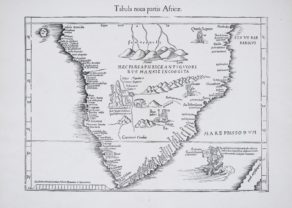
Southern Africa – Tabula Nova Partis Africae
by Lorenz Fries (after Martin Waldseemüller)Price (without VAT, possibly to be added): €1 200,00 / $1 332,00 / £1 068,00Discover the age of discoveries
-
Cape of Good Hope – Das Vorgebirg Der Guten Hofnung
by F.A. Scraembl, L.S. De la RochettePrice (without VAT, possibly to be added): €800,00 / $888,00 / £712,00Exceptional beauty
You may also be interested in:

[Untitled] Japan
by
Benedetto Bordone
Price (without VAT, possibly to be added): €2 800,00 / $3 108,00 / £2 492,00
Very rare: oldest map of Japan, and … based on Polo’s description

Jan Mayen – Insulae Johannis Mayen Cum universe situ Sinuum et Promontariorum
by
Joan Blaeu, Johannes Janssonius
Rare Spanish edition

Luxembourg, Duchy
by
Abraham Ortelius
Price (without VAT, possibly to be added): €750,00 / $832,50 / £667,50

Map of the Moon – Tabula Selenographica in qua Lunarium
by
Johann Gabriel Doppelmayr
Price (without VAT, possibly to be added): €3 500,00 / $3 885,00 / £3 115,00
The unique and famous first comparative chart of the Moon (with double competing nomenclature) from which the names of many lunar features have been derived.
Let’s dream away
This superb chart was made by Johannes van Keulen in 1740/1753, but later also published by Robert Laurie and James Wittle in 1797 in London.
A central compass rose orients north to the left and there are scales in Dutch miles and sea leagues. A wealth of detail shows the meandering course of the Salt River entering the bay just east of Capetown which is shown in detail with the fort, Company Gardens and the Gallows highlighted. Further one notices Table Mountain, flanked by Devil’s Mount and Lyon’s Mount. In the bay the Anchoring Ground and Robben Island are surrounded by depth soundings and to the top left there is an inset engraving “A South View of the Cape bt Monsieur L’Abbé de la Caille”.
Laurie & Whittle refers to the partnership of Robert Laurie (1755?-1836) and James Whittle (1757-1818), engravers and map publishers. Both men were employed by Robert Sayer (ca. 1724-1794), one of the most prominent British publishers and map sellers of the eighteenth century. Sayer died in 1794 and his business was taken over by his assistants. The two worked together as Laurie & Whittle until 1812, when Laurie retired. They were especially known for publishing sea charts and maritime atlases. From 1812-1818, when he died, Whittle worked with Laurie’s son, Richard Holmes Laurie, as Whittle & Laurie. After 1818, the firm was known as R. H. Laurie, even though Richard died in 1858. Later, the firm was managed by Laurie’s draughtsman, Alexander George Findlay, and, later, Daniel and William Kettle.
The map includes a plethora of detail about the colony that was previously unrecorded in charts of the area. For instance:
Original title: Kaart van de Tafel Baay vertoonende De Reede van C. De Goede Hoop
The VOC Secret Atlas
The so-called “Secret Atlas” of the Dutch East India Company was, in fact, Part VI of the Zee-Fakkel, published by Johannes (II) Van Keulen, from 1753. For the first 150 years of the Company’s history, the VOC had resisted producing printed sea charts of the area east of South Africa, which the VOC saw as their proprietary region. By keeping these charts secret, the best available navigational information and coastal details would remain proprietary. To this end, manuscript charts were produced with proprietary information by the likes of Isaak de Graaf.
The Secret Atlas (Volume VI of the Zee-Fakkel), like the VOC manuscript maps before it, was never offered for sale to the public and was only issued to VOC ships, with explicit instructions that the charts must be returned at the completion of each voyage.
It is interesting to note that Sayer & Bennett published a nearly identical version of the map and credited Van Keulen with its production. This shows that decades after it had first been issued, the Van Keulen name and the VOC knowledge contained on the chart still carried real weight among the British public. The knowledge was still worth keeping secret — and worth stealing!