
Cape of Good Hope – Das Vorgebirg Der Guten Hofnung
by
L.S. De la Rochette, F.A. Scraembl
Exceptional beauty
Detail
Date of first edition: ca. 1782
Date of this map: ca. 1789
Dimensions (not including margins): 32 x 48 cm
Condition: Very good. Strong paper and very wide margins .
Condition rating: A+
Verso: blanc
Price (without VAT, possibly to be added): €800,00 (FYI +/- $888,00 / £712,00)
Unless otherwise specifically stated on this map page, we charge the following expedition costs in euro (unfortunatelly, gone up with Covid, but still too low in reality!):
– Benelux: 40 euro
– Rest of Europe: 60 euro
– Rest of the World: 100 euro
In stock
Related items
-
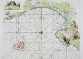
Chart of Cape of Good Hope
by Robert Laurie & James Wittle, Johannes II van KeulenPrice (without VAT, possibly to be added): €2 250,00 / $2 497,50 / £2 002,50Superb and scarce
-
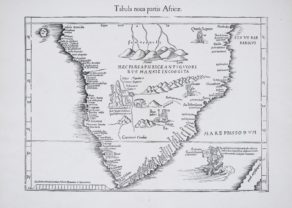
Southern Africa – Tabula Nova Partis Africae
by Lorenz Fries (after Martin Waldseemüller)Price (without VAT, possibly to be added): €1 200,00 / $1 332,00 / £1 068,00Discover the age of discoveries
You may also be interested in:

Cuzco (Inca capital)
by
Giovanni Battista Ramusio
Price (without VAT, possibly to be added): €850,00 / $943,50 / £756,50
Rare first edition (block destroyed by fire)

Avignon
by
Georg Braun and Frans Hogenberg
Papal city²

Map of the Moon – Tabula Selenographica in qua Lunarium
by
Johann Gabriel Doppelmayr
Price (without VAT, possibly to be added): €3 500,00 / $3 885,00 / £3 115,00
The unique and famous first comparative chart of the Moon (with double competing nomenclature) from which the names of many lunar features have been derived.

Bristol – Brightstowe, Vulgo; Quondam Venta, Florentissimum
by
Georg Braun and Frans Hogenberg
Price (without VAT, possibly to be added): €900,00 / $999,00 / £801,00
A large and detailed map of the Dutch colony
This is a scare Austrian version of a finely engraved and very detailed map of the Cape after de la Rochette, more commonly seen in its original English edition, first published by Faden in 1782, or later by Wyd. The map extends from St. Helena Bay to False Bay and has a decorative title piece showing an elephant hunt. Approximately twenty farms and individual settlements are named as are Constantia and Stellenbosch. Topography is well depicted, with the Drakenstein Mountains boldly engraved along the eastern coastline. This is one of the most detailed of the region of its time and the depiction of relief is particularly effective.