

")

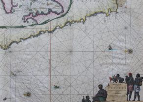
Chart of the Congo River and the coast of Angola
by
Johannes van Keulen
Detail
Date of first edition: 1697-1709
Date of this edition: 1697-1709
Dimensions (not including margins): 50,4 x 57,3 cm
5Dimensions (including margins): 52,2 x 61 cm
Condition: Very good. Sharp copper engraving printed on paper. Centre fold as published. Age-toned. Old outline colouring. Wide margins, with exception of top.
Condition rating: A
Verso: blank
Map reference: Koeman, Keu 145;
From: De Nieuwe Groote Lichtende Zee-Fakkel, Amsterdam 1697-1709
Price (without VAT, possibly to be added): €700,00 (FYI +/- $777,00 / £623,00)
Unless otherwise specifically stated on this map page, we charge the following expedition costs in euro (unfortunatelly, gone up with Covid, but still too low in reality!):
– Benelux: 40 euro
– Rest of Europe: 60 euro
– Rest of the World: 100 euro
In stock
Related items
You may also be interested in:

Luxembourg, Duchy
by
Abraham Ortelius
Price (without VAT, possibly to be added): €750,00 / $832,50 / £667,50

Avignon
by
Georg Braun and Frans Hogenberg
Papal city²

Portrait Abraham Ortelius, by Galle
by
Abraham Ortelius, Philip Galle
Price (without VAT, possibly to be added): €800,00 / $888,00 / £712,00

Cuzco (Inca capital)
by
Giovanni Battista Ramusio
Price (without VAT, possibly to be added): €850,00 / $943,50 / £756,50
Rare first edition (block destroyed by fire)
Full title: Pas Caert vande Custen van Angola van Rio de Zaire tot C. Negro
Note: The chart with item number 21002 is adjacent to this one.