


Chart of the southwestern coast of Africa
by
Johannes van Keulen
Detail
Date of first edition: 1683
Date of this map: 1697-1709
Dimensions (not including margins): 50,5 x 57,5 cm
Dimensions (including margins): 53,6 x 52 cm
Condition: Very good. Strong paper and sufficient margins. Centre fold as published. Signs of water stains at verso, not visible at recto.
Condition rating: A
Verso: blank
From: De Nieuwe Groote Lichtende Zee-Fakkel, 1697-1709
Price (without VAT, possibly to be added): €800,00 (FYI +/- $888,00 / £712,00)
Unless otherwise specifically stated on this map page, we charge the following expedition costs in euro (unfortunatelly, gone up with Covid, but still too low in reality!):
– Benelux: 40 euro
– Rest of Europe: 60 euro
– Rest of the World: 100 euro
In stock
Related items
-

Cape of Good Hope – Das Vorgebirg Der Guten Hofnung
by L.S. De la Rochette, F.A. ScraemblPrice (without VAT, possibly to be added): €800,00 / $888,00 / £712,00Exceptional beauty
-
Chart of Cape of Good Hope
by Johannes II van Keulen, Robert Laurie & James WittlePrice (without VAT, possibly to be added): €2 250,00 / $2 497,50 / £2 002,50Superb and scarce
You may also be interested in:

Map of the Moon – Tabula Selenographica in qua Lunarium
by
Johann Gabriel Doppelmayr
Price (without VAT, possibly to be added): €3 500,00 / $3 885,00 / £3 115,00
The unique and famous first comparative chart of the Moon (with double competing nomenclature) from which the names of many lunar features have been derived.

Chart of the Gulf of Finland
by
Lucas Janszoon Waghenaer

Jan Mayen – Insulae Johannis Mayen Cum universe situ Sinuum et Promontariorum
by
Joan Blaeu, Johannes Janssonius
Rare Spanish edition

Edinburgh
by
Georg Braun and Frans Hogenberg
Price (without VAT, possibly to be added): €1 700,00 / $1 887,00 / £1 513,00
South Africa – Namibia – Angola: what’s in a map
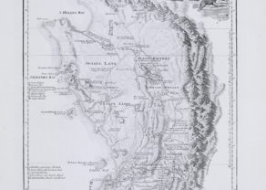
The Costa the Caffres (see Note 1) on a scale of 1: 4,500,000, shows the western coast between Cabo Negro (now in Angola) and Cabo the Bona Esperança. This chart was first published in the fifth part of De Nieuwe Groote Lichtende Zee-Fakkel in 1683. The north is left. The scale bar is in Duytsche, Spaense and Engelse mylen. Johannes van Keulen mentions his privilege for fifteen years in the cartouche.
It is a misconception that the Cape of Good Hope is the most southern tip of Africa. This honor goes to is C. Aguilhas (Cape Agulhas; see Note 2), some 170 km southeast of Cape of Good Hope (the left inset). Most topographical names are Portuguese. Saldanha Bay, shown in the inset is located about 100 km north of Cape Town. Its name is derived from a captain in the fleet of Albuquerque that visited South Africa in 1503. The bay of Angra Pequena, visited by Bartolomeu Diaz in 1487, is currently known as Lüderitz, the German Adolf Lüderitz purchased this region in 1883. Approximately on the Tropic of Capricorn one notices Pa do Ilheo, now Spencer Bay. Also in Namibia lies G. Frio, today Angra Fria.
The Visch Bay refers to current Baia dos Tigres, the largest island of Angola.
Original title: Pascaert van de Costa Caffres
Bottom left one sees the island of St. Helena! Cape of Good Hope was first reached by Portuguese Bartolomeu Diaz on March 12, 1488. Due to his own route and stormy weather he did not realize that he had rounded Cape of Good Hope and Cape Agulhas. He would sail to the Agulhas Current, a warm ocean current in the southwest Indian Ocean.
The first Dutch settlement on the southern Cape goes back to the shipwreck of the Dutch ship Nieuw Haarlem in March 1647. The castaways built a small fort which they named Zand Fort. Between 1652 and 1795 the Cape of Good Hope served as a refreshment station for ships of the Dutch East India Company. When the Netherlands became a satellite state of France, Britain took the opportunity to seize power in this region.
Note 1: The word “Caffre” is derived from the Arabic kafir and refers to an unbeliever. In English it is a racist and insulting term to describe a black African. In Dutch the words uitkafferen (to scold) and keffer (an annoying dog) have the same origin.
Note 2: The International Hydrographic Organization draws the border to the south between the Atlantic and the Indian Ocean. The westerly situated Cape of Good Hope therefore lies in the Atlantic Ocean.
Note 3: The chart with item number 21006 is adjacent to this one