


Four unique maps: the Portuguese going for spices
Detail
1) For Aden, Mombaza (Mombasa), Quiloa (Kilwa Kisiwana), Cefala (Nova Sofala)
Date of first edition: 1572
Date of this edition: probably 1574 (second state: cum privilegio)
Dimensions (not including margins): 33 x 46,5 cm
Dimensions (including margins): 37 x 49,5 cm
Condition: Good. Nice colouring. Centre fold as published. Good margins. Natural age-toning. Verso left on top in margin: professionally restored, not visible on recto.
Condition rating: A
Verso: text in German
Map reference: Van der Krogt, IV, 2-1, 40; Taschen, Br. Hog. p.126
From: Civitates Orbis Terrarum, Liber Primus. Van der Krogt IV, 41:2-3, page 54
2) For Calechut (Kozhikode, also known as Calicut), Ormus (Hormuz), Canonor (Kannur), Elmina;
Date of first edition: 1572
Date of this edition: 1575 (second state: cum privilegio)
Dimensions (not including margins): 33,5 x 47 cm
Dimensions (including margins): 40,2 x 52,3 cm
Condition: Very good. Nice original colouring. Centre fold as published. Wide margins. Natural age-toning.
Condition rating: A+
Verso: text in Latin
Map reference: Van der Krogt IV, 2-1, 4253; Taschen, Br. Hog. p.129
From: Civitates Orbis Terrarum, Liber Primus. Van der Krogt IV, 2-1, 41:1, page 57
3) For Tingis (Tangier), Tzaffin (Safi), Septa (Ceuta), Arzilla (Assilha), Sala (Chella, part of Rabat)
Date of first edition: 1572
Date of this edition: 1575 (second state: cum privilegio)
Dimensions (not including margins): 33 x 47,5 cm
Dimensions (including margins): 40,5 x 54 cm
Condition: Very good. Nice colouring. Centre fold as published. Natural age-toning.
Condition rating: A
Verso: text in Latin
Map reference: Van der Krogt IV, 4253; Taschen, Br. Hog. p.123
From: Civitates Orbis Terrarum, Liber Primus. Van der Krogt IV, 41:1.1, 56
4) For Anfa (Casablanca), Azamor (Azemmour), Diu and Vellha Goa (Old Goa)
Date of first edition: 1572
Date of this edition: 1575 (second state: cum priviligio)
Dimensions (not including margins): 34 x 47 cm
Dimensions (including margins): 42 x 53,2 cm
Condition: Very good. Nice old colouring. Centre fold as published. Wide margins.
Condition rating: A+
Verso: text in Latin
Map reference: Van der Krogt IV, 2-1, 805; Taschen, Br. Hog. p.133
From: Civitates Orbis Terrarum, Liber Primus. Van der Krogt IV, 2-1, 41:1, page 57.
In stock
Braun on Aden, Casablanca, Tangier, Diu and Goa….
ADEN
TRANSLATION OF CARTOUCHE TEXT: Aden, famous centre of trade in Arabia, where merchants meet from India, Ethiopia and Persia. Aden is a magnificent town, well fortified due to its location and construction, famed for the beauty and number of its buildings, protected by ramparts and high mountains, on whose summits flaming torches show mariners the harbour. It was formerly a peninsula, but as a result of human industry is now completely surrounded by waters.
COMMENTARY BY BRAUN: “All those travelling to Mecca come here, and as soon as a ship sails into the harbour, the sultan’s soldiers arrive and inquire as to where they have come from, what goods they are carrying with them, how long they have been under sail and then confiscate the mast, the sails and the like. They do that so that the ships cannot leave without paying the toll.”
The semicircular shape of the island is easily recognizable; the mountains around the city are topped by fortified strongholds and the city is lent an oriental character by its eye-catching red domes. Boats are being repaired on the shore, and the ships sailing past in the foreground also underline Aden’s position as a controlling body in the Gulf. In the 13th century, according to Marco Polo, the city had a population of 80,000. With the shifting of the trade routes in the wake of the Portuguese discoveries, Aden went into an economic decline; in 1548 it was conquered for the Ottoman Empire by Piri Reis, the admiral of the Ottoman fleet. Aden is today a city in Yemen with 550,000 inhabitants.
CASABLANCA (ANFA)
CAPTION: Anfa, called Anafa by some.
COMMENTARY BY BRAUN (on verso): “Anfa is a large city that was built by the Romans on the shores of the sea and whose location was as good as any city in all Africa. It was razed to the ground for two reasons, however, firstly because it strove too vigorously for freedom and secondly because it caused both Cadiz and the Portuguese much trouble with its pirate ships. The King of Portugal therefore sent 50 well-armed ships to the city, from which the inhabitants fled with all that they could carry. The captain led his forces into the city and in one day laid waste to it and burned the houses to ashes and razed the walls to such an extent that it has remained uninhabited right up to the present.”
The engraving shows the ravaged city after 1486. The Berbers arrived in the area as early as the 7th century; their settlement subsequently evolved into the small independent Kingdom of Anfa, which in the 14th century became a major port. In 1486 Anfa was destroyed by the Portuguese, who in 1515 used its ruins to build a fort, called Casablanca, after the nearby burgeoning town of the same name.
CEUTA
COMMENTARY BY BRAUN: “Ceuta, called Seupta by the Portuguese, was built by the Romans on the shores of the Sea of Hercules and was formerly the capital of Mauretania, which is why the Romans regarded it so highly. It was later taken by the Goths and a prince was installed, under whose rule it remained until the Muslims came to Mauretania and subjugated this city too.”
The engraving shows that only a small promontory in the north of the peninsula was inhabited. Ceuta, which measures 18 sq. km, lies on a peninsula on the coast of North Africa, near the Strait of Gibraltar. There were three reasons for its conquest by Portugal in 1415: firstly, the peninsula had become a threat due to its location on the Strait of Gibraltar, where it could potentially provide the Muslims with a stepping-stone to Europe. Secondly, Ceuta was an important trading port via which goods from Africa, in particular gold, were brought to Europe. Thirdly, the peninsula offered Portugal a gateway to the unknown continent of Africa. Part of Spain since 1668, the autonomous city of Ceuta is today home to 4,000 inhabitants.
DIU
COMMENTARY BY BRAUN (on verso): “Diu is an island and also the name of a lovely town that formerly lay under the rule of the city and district of Khambat. Diu lies at the entrance to the Gulf of Cambaia in the Indian Ocean and was fought for and eventually won by the Christians with 23 ships with particular trouble and effort, because Diu had the king of Cambaia, Aden and Calicut on its side.”
The engraving shows Diu in cavalier perspective from the sea. The town is encircled by secure ramparts, from which three jetties lead out into the water. Rising above its severely geometric skyline are a number of tall towers that served as look-out posts. The fort at the eastern end of the island, on the right-hand of the picture, was built in 1535. Diu is a small town situated on an island measuring 15 square miles in western India. In the naval battle of Diu, waged in 1509 against a combined fleet of Egyptian, Arab and India forces, it was conquered by the Portuguese. This victory secured Portugal’s supremacy in the Indian Ocean.
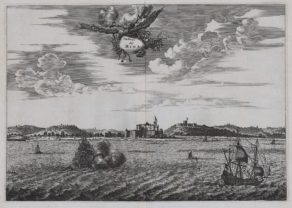
MOMBASA
COMMENTARY BY BRAUN: “Mombasa was conquered by force by the Christians in the year 1505. For when Francisco de Almeida was sent to India by the King of Portugal to levy duties from the inhabitants, the Africans rebelled violently against him. As a consequence the Christians destroyed the town and burned it right down to the ground. The ruler escaped with his life, the other inhabitants were all killed.”
The illustration shows a stereotypical view of a small town on an island. While the architecture, with its tall towers and red roofs, is not very African, the palm trees are more typical of the local vegetation. The picture and the description suggest that little was known about Mombasa.The town was reached by the Portugese explorer Vasco da Gama in 1498 and conquered by Portuguese troops under Francisco de Almeida in 1505. Mombasa lies on Mombasa Island off the east coast of Africa and is today Kenya’s second-largest city.
OLD GOA (VELHA GOA)
CAPTION: Goa, the fortified city in India, came into the power of the Christians in 1509.
Goa, which lies on a peninsula, is seen across the Mandovi River delta in front of the open sea. A naval battle is depicted on the right: after the Portuguese had discovered the sea route to India in 1489, they used the enmities between the various Indian regional kingdoms to their advantage and in 1510 conquered Goa. The city became the colonial capital of Portuguese India. Portugal would maintain possession of Goa and the surrounding area for 450 years. Old Goa, or Velha Goa, as the city is now called, is the capital of Goa, India’s smallest state, with 1.45 million inhabitants.
TANGIER (TANJA)
COMMENTARY BY BRAUN: “Tingis, which the Portuguese call Tanigara, is a large and ancient city, situated not far from the western Mediterranean. At the time when the Goths ruled over Granada it was under the rule of the chief of the city of Septa [Ceuta], until Arzilla [Asilah] was brought under the rule of the Muslims; it has always been beautifully adorned, noble and very well built with many splendid works of architecture.”
The engraving shows a fortified town, whereby only half the area within the walls is built up. The large building in the background may be the governor’s residence. In 1471 the Portuguese attacked Asilah, whose inhabitants fled to Tangier. But that same year Tangier, too, was conquered, and remained in Potuguese hands until 1580. Tangier today belongs to Morocco and has a population of 670,000.
Related items

You may also be interested in:

Lisbon

Toledo (Castile) – Toletum

Asia Secunda pars Terrae in Forma Pegasi

Map of the Moon – Tabula Selenographica in qua Lunarium
The unique and famous first comparative chart of the Moon (with double competing nomenclature) from which the names of many lunar features have been derived.
Portuguese going for spices
The vast majority of the views in the city atlas of the world of Braun and Hogenberg are “European”. A few non-European views are quite famous such as the double vision Cuzco-Mexico and Jerusalem.
Equally intriguing are the four copper plates with 17 locations that played a major role in the Portuguese search for spices. All four sheets were published at the end of the first edition of the atlas published in 1572/1575. The following 17 trade settlements are shown:
1) Aden, Mombaza (Mombasa), Quiloa (Kilwa Kisiwana), Cefala (Nova Sofala);
2) Calechut (Kozhikode, also known as Calicut), Ormus (Hormuz), Canonor (Kannur), Elmina;
3) Tingis (Tangier), Tzaffin (Safi), Septa (Ceuta), Arzilla (Assilha), Sala (Chella, part of Rabat)
4) Anfa (Casablanca), Azamor (Azemmour), Diu; Goa.
It strikes that all these cities are located in three areas: Morocco, East Africa and India. Braun and Hogenberg did not provide any illustration of places/ports between Ghana and Mozambique!