


Black Sea in the Antiquity – Pontus Euxinus…
by
Abraham Ortelius
Detail
Date of first edition: 1590
Date of this map: 1601
Verso: text in Latin
Dimensions (not including margins): 35,6 x 50,2 cm
Dimensions (including margins): 46,6 x 56,6 cm
Condition: excellent. Sharp copper engraving printed on strong paper. Centre fold is as published. Old coloured. Natural age-toning. Wide margins.
Condition rating: A+
Verso: text in Latin
Map reference: Van der Krogt III, 0350H:31; Van den Broecke 213
From: Theatrum Orbis Terrarum, first published 1590, this edition 1601, Plantin, Antwerpen; Van der Krogt III, 1:052: verso mentions ‘xxv’
Price (without VAT, possibly to be added): €1 000,00 (FYI +/- $1 110,00 / £890,00)
Unless otherwise specifically stated on this map page, we charge the following expedition costs in euro (unfortunatelly, gone up with Covid, but still too low in reality!):
– Benelux: 40 euro
– Rest of Europe: 60 euro
– Rest of the World: 100 euro
In stock
Related items
You may also be interested in:

Scotland – Nova Scotia
by
Willem and Joan Blaeu
Price (without VAT, possibly to be added): €1 000,00 / $1 110,00 / £890,00
A nice map of Scotland

Jan Mayen – Insulae Johannis Mayen Cum universe situ Sinuum et Promontariorum
by
Joan Blaeu, Johannes Janssonius
Rare Spanish edition

Lucca
by
Georg Braun and Frans Hogenberg
Price (without VAT, possibly to be added): €700,00 / $777,00 / £623,00

San Adrian (Navarre) – La Sierra de Sant Adrian en Biscaia
by
Georg Braun and Frans Hogenberg
Price (without VAT, possibly to be added): €700,00 / $777,00 / £623,00
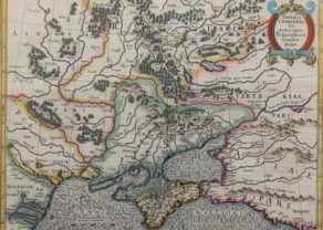
The Black Sea by Ortelius, where history never ends…
The map is oriented northward, with the directions carefully noted in the center of each edge of the map. The entirety of the Black Sea is displayed, as well as the surrounding regions, including present-day Turkey and Armenia (Bithynia, Galatia, Cappadocia, Armeniae Pars), Georgia and Russia (Colchis, Sarmatiae Asiaticae pars), Ukraine (Scythiae sive sarmatiae Europaeæpa), the Crimean peninsula (Taurica quae et scythica chersonesus), Moldova, Romania, and Bulgaria (Getae, Daciae pars, Pontus Moesia), and Greece (Thraciae pars). The smaller water body connected to the Black Sea to the north is Maeotis Palus (the Maeotis Swamp or Lake Maeotis), which is today known as the Sea of Azov (and sine recently closed off by Russia). The sea is colored an appropriate dark grey while the other regions are differentiated by color, alternating between pink, green, and yellow.
This map is characterized by excellent attention to detail. The shape of the coastlines and rivers are carefully rendered, and throughout the map mountain ranges and forests give the land texture. Cities are represented with unique drawings in dark red. Each aspect of the map is labeled, and some labels give additional information about the name or events that occurred there. This indicates the map’s use as a reference for the region in both geography and history.
The two cartouches, one containing the title and date and the other the map’s creator, are sharply rendered and brightly colored in red, blue, and yellow. The ornamented edges curl out and are shaded so as to give them a three-dimensional quality that pops from the page. In particular, the decorative title cartouche takes up a large part of the land on the eastern area of the map. The title of the map, Pontus Euxinus, is Latin for “hospitable sea,” a euphemism for the earlier name “inhospitable sea,” as the Black Sea was known for its stormy weather, harsh currents, and lack of islands to visit. Also found in the cartouche is the phrase “Aequor Iasonio pulsatum remige primum,” indicating that this was the sea first traveled by Jason, the ancient Greek hero who sailed to find the Golden Fleece. This places the map firmly in the realm of classical mythology.
The map includes many interesting locations important to Greek mythology. Phryxis’ temple is located on the Phasis river in Colchis (in the southeast corner of the map), which was the location of the Golden Fleece, the object of Jason’s quest. Themiscyra, home to the Amazons and a city visited by Heracles during his Nine Labours, is also present on the southern shore of the Black Sea, between the Iris and Thermodon rivers. There are also numerous cities named for Greek gods and heroes, such as Apollonia Magna on the Thracian coast and Heraclea near the mouth of the Acheron river in Bithynia.