


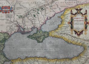
Ukraine & Crimea – Taurica Chersones VS. nostra Aetate Przecopsca et Gazara Dicitur
Detail
Date of first edition: 1595 (made by Gerard Mercator)
Date of this map: 1613-1616 (published by Jodocus Hondius jr.)
Dimensions (not including margins): 31,5 x 40 cm
Condition: Very good copper engraving. Centre fold as published. Strong paper and wide margins. Minor repair in left bottom corner.
Condition rating: A
Verso: text in French
Map references: Van der Krogt 1, 1890:1A.1.
From: Gerardi Mercatoris – L’Atlas ou Méditations Cosmographiques de la Fabrique du Monde et Figure diceluy. Amsterdam, J. Hondius jr., 1613-16. Van der Krogt 1, 112
In stock
Related items
You may also be interested in:

Map of the Moon – Tabula Selenographica in qua Lunarium
The unique and famous first comparative chart of the Moon (with double competing nomenclature) from which the names of many lunar features have been derived.

Bristol – Brightstowe, Vulgo; Quondam Venta, Florentissimum

Chester – Cestria vulgo Chester, Angliae Civitas

[Untitled] Japan
Very rare: oldest map of Japan, and … based on Polo’s description
Ukraine and Crimea, where history never stops
Taurica Chersonesus refers to the Greek colony Chersonesos of Taurica (Crimea =). Crimea seu Tart Aris Przecopensis on the mainland then refers to the city of Perekop, located on the isthmus between the mainland and peninsula.
This map, which covers a vast area, shows the influence of history on the geography. Virtually no border has stood the test of time. Central on the map is the Khanate of Crimea; a state that split from the Khanate of the Golden Horde in 1441 and would continue to do so until 1783. Thus the Crimean Khanate was the last remaining successor to the Khanate of the Golden Horde. The original state of the Golden Horde is in the east ( “Tartariae Pars”). From the north threatens Moskow: In 1547 was Grand Duke Ivan IV became the first Tsar of Russia. He forced the western Lithua to enter into a defensive Commonwealth Podolia of 1569 at the Lublin Union; This alliance led to the Polish-Lithuanian Commonwealth would last for 200 years and would only be extinguished by the Polish Fractions. Ukraine belonged largely to this state.
A consequence of Union was that the area east of the Dnieper (see Kioff) gradually became Russian (what consequences to current days). Moldaviae Pars, with the delta of the Danube, was under Ottoman control. Podolia (Podolia) is one of the many European historic areas which alternately is part several countries with occasional moments of semi-independence. The Krim Khanate (the Crimea and included the coastal areas of Ukraine) was not part of the Commonwealth.
This map (with the scale 1: 3,500,000) was published posthumously in its third atlas of 1595. This specimen comes from the French Mercator-Hondius edition of 1613/1616. Blaeu renewed map from 1634 with major political changes.