
Planisphaerium Coeleste
by
Tobias Conrad Lotter
Detail
Date of first edition: ca. 1720
Date of this edition: ca. 1720
Dimensions (not including margins): 48 x 57 cm
Condition: good. Sharp copper engraving. Centre fold as published. Left extra fold. Margins top and left, smaal bur sufficient for framing.
Condition rating: A
Verso: blank
From: Atlas Novus. Warner, p. 164.
Unless otherwise specifically stated on this map page, we charge the following expedition costs in euro (unfortunatelly, gone up with Covid, but still too low in reality!):
– Benelux: 40 euro
– Rest of Europe: 60 euro
– Rest of the World: 100 euro
This item is sold
Related items
-

Constellations of the Northern and Southern Hemispheres
by J.C. BackPrice (without VAT, possibly to be added): €525,00 / $582,75 / £467,25 -
The Eastern Hemisphere – Hemisphaerium Orbis Antiqui
by Andreas Cellarius, Johannes JanssoniusPrice (without VAT, possibly to be added): €2 800,00 / $3 108,00 / £2 492,00

You may also be interested in:

Chester – Cestria vulgo Chester, Angliae Civitas
by
Georg Braun and Frans Hogenberg
Price (without VAT, possibly to be added): €900,00 / $999,00 / £801,00

Edinburgh
by
Georg Braun and Frans Hogenberg
Price (without VAT, possibly to be added): €1 700,00 / $1 887,00 / £1 513,00

Scotland – Nova Scotia
by
Willem and Joan Blaeu
Price (without VAT, possibly to be added): €1 000,00 / $1 110,00 / £890,00
A nice map of Scotland

China, Tartary and Japan
by
Lorenz Fries (after Martin Waldseemüller)
Price (without VAT, possibly to be added): €4 000,00 / $4 440,00 / £3 560,00
The first modern map of China printed in Europe
Lotter
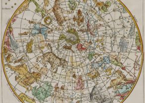
The chart is centred on the North and South Poles, with smaller circular diagrams illustrating the theories of Tycho, Ptolemy, Landsbergen and Copernicus, two armillary spheres, 2 terrestrial globes, showing the inter-relation of the moon and tides, the illumination of the moon by the sun and the path of the earth around the sun.
Tobias Lotter was born 1717 in Germany. He became a publisher and engraver in Augsburg. He was engaged by Matthäus Seutter the elder as an engraver and married his daughter. He also was successful with his own business and became one of the better known German cartographers. After his death in 1777, the business was continued by his son Matthias Albrecht Lotter.