


Comitatus Flandriæ Nova Tabula
by
Henricus Hondius
Detail
Date of first edition: 1636 (Henricus Hondius)
Date of this map: 1637
Dimensions (not including margins): 41,3 x 52,7 cm
Condition: Very good. Centre fold as published. Old colour. Strong print and clear image.
Condition rating: A
Verso: text in Latin
Map reference: Van der Krogt 1, 3200:1B.1
From: Appendix Novi Atlantis (the so-called Mercator-Hondius-Janssonius atlas). Van der Krogt 1:301
Price (without VAT, possibly to be added): €450,00 (FYI +/- $499,50 / £400,50)
Unless otherwise specifically stated on this map page, we charge the following expedition costs in euro (unfortunatelly, gone up with Covid, but still too low in reality!):
– Benelux: 40 euro
– Rest of Europe: 60 euro
– Rest of the World: 100 euro
In stock
Related items
You may also be interested in:

Cuzco (Inca capital)
by
Giovanni Battista Ramusio
Price (without VAT, possibly to be added): €850,00 / $943,50 / £756,50
Rare first edition (block destroyed by fire)

Luxembourg, Duchy
by
Abraham Ortelius
Price (without VAT, possibly to be added): €750,00 / $832,50 / £667,50

Scotland – Nova Scotia
by
Willem and Joan Blaeu
Price (without VAT, possibly to be added): €1 000,00 / $1 110,00 / £890,00
A nice map of Scotland

Chart of the Gulf of Finland
by
Lucas Janszoon Waghenaer
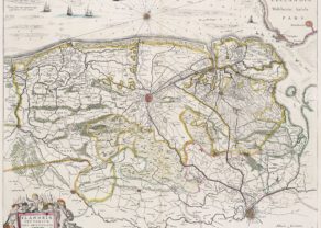
Flanders and Zeeland
This handsome copper engraved map details the coastline from Calais to Zeeland, and east to Brussels and Leuven. Beautifully engraved and highly detailed, the map shows forests, roads and canals, hundreds of tiny villages and numerous fortified towns including Brussels, Gent and Antwerp. Fishing banks are shown off the coast. The map is adorned with the coat of arms for Flanders and a beautiful title cartouche with a pair of cherub “soldiers.” Dedicated to Dr. Ionni d’Hondt, cousin of Henricus.