


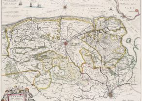
Pars Flandriae Teutonicae occidentalior
Detail
Date of first map: 1631 (Willem Blaeu)
Date of this map: 1644-1655 (Joan Blaeu)
Dimensions (without margins): 39,8 x 50 cm
Dimensions (with margins): 49,3 x 57,3
Condition: Excellent. Sharp copper engraving. Centre fold as published, flattened. Very wide margins. Originally coloured.
Condition rating: A+
Verso: text in Latin
Map reference: van der Krogt 3200:2
From: Theatrum Orbis Terrarum; van der Krogt 2:202-3
In stock
Pars Flandriae Teutonicae
This map shows part of the Duchy of Flanders, of which some is currently situated in France. The western part of Teutonic Flanders, spreading from Nieuwpoort to Gravelines, follows the ‘Flandriae Teutonicae Pars Orientalior’.
This map forms a duo with Flandriae Teutonicae pars Orientalior of Willem Blaeu..
Related items
You may also be interested in:

Avignon
Papal city²

Lucca

Map of the Moon – Tabula Selenographica in qua Lunarium
The unique and famous first comparative chart of the Moon (with double competing nomenclature) from which the names of many lunar features have been derived.

Jan Mayen – Insulae Johannis Mayen Cum universe situ Sinuum et Promontariorum
Rare Spanish edition