


Amsterdam (expansion)
by
Georg Braun and Frans Hogenberg
Rare and exceptional
Detail
Date of first edition: 1617 (sixt and final volume)
Date of this map: 1617
Dimensions (no including margins): 27,5 x 38,5 cm
Dimension (including margins): 38,5 x 51 cm
Condition: Very good. Strong paper and wide margins
Condition rating: A
Verso: text in Latin, traces of previous framing
Map reference: Van der Krogt IV, 2-1, 108
From: Theatri Praecipuarum Totius Mundi Urbium, Liber Sextus; Van der Krogt IV, 2-1, 41:1-3, page 20
Unless otherwise specifically stated on this map page, we charge the following expedition costs in euro (unfortunatelly, gone up with Covid, but still too low in reality!):
– Benelux: 40 euro
– Rest of Europe: 60 euro
– Rest of the World: 100 euro
This item is sold
Related items
You may also be interested in:

Edinburgh
by
Georg Braun and Frans Hogenberg
Price (without VAT, possibly to be added): €1 700,00 / $1 887,00 / £1 513,00

The Eastern Hemisphere – Hemisphaerium Orbis Antiqui
by
Johannes Janssonius, Andreas Cellarius
Price (without VAT, possibly to be added): €2 800,00 / $3 108,00 / £2 492,00

Toledo (Castile) – Toletum
by
Georg Braun and Frans Hogenberg
Price (without VAT, possibly to be added): €1 500,00 / $1 665,00 / £1 335,00

Lisbon
by
Georg Braun and Frans Hogenberg
Price (without VAT, possibly to be added): €1 300,00 / $1 443,00 / £1 157,00
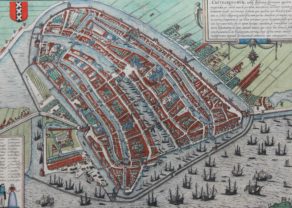
Amsterdam or the genese of a world city
While the normal (and well know) view of Amsterdam was published in their first volume of the atlas in 1572, this one was only ready for the final and sixth part of the atlas.
Amsterdam would undergo four urban expansions between 1578 and 1665. This plan shows Amsterdam after the second expansion and during the development of the next phase.
During the first expansion the city was mainly extended to the east (left). From St Anthonispoort (now Waag) was beyond the Oude Schans, a new district in the east built on three island (Uyllenburg, Marcken and Rapenburg). Between the gate and the islets new streets were built.
During the second phase explained in the West (right) the Singel (De Cingel) was incorporated within the city walls and a narrow canal was dug (the Herengracht) just inside the ramparts. No Westerkerk (cfr Anna Frank) yet: it was only built between 1620 and 1631.
The third and fourth expansions were particularly spectacular and would fill the entire urban area to the city wall at the Singel canal, with many small channels are projected towards the Singel. At the right this print also shows the lonely Charthusian monastery (St. Andries-ter-Zaliger-Haven), founded in the 14th century, but destroyed by fire in 1572. This part of the city is now the Jordaan.
One notices the outlined sketch of the Singel expansion at the left!
Full title: -Amstelodam in quo sdes Sacrae, Curia Hospitalia…