


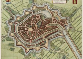
Breda
Detail
Date of first edition: 1649 (Latin edition)
Date of this map: 1652
Dimensions (not including margins): 42 x 53,5 cm
Dimensions including margins): 48 x 59,2 cm
Condition: Excellent. Lovely colouring. Strong paper and wide margins. Centre fold as published.
Condition rating: A+
Verso: text in Dutch
Map reference: Van der Krogt IV-2,1, 600; Fauser #1817
From: Tonneel der steden van de Vereenighde Nederlanden met hare beschrijvingen, Amsterdam, J. Blaeu, 1652. Van der Krogt IV-2,1, 43:121
In stock
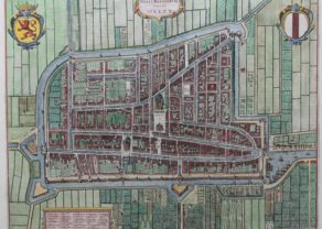
Dedication to Frederik Hendrik
Joan Blaeu dedicated this map to Frederik Hendrik (see picture).
He (29 January 1584 – 14 March 1647) was the sovereign prince of Orange and stadthouder of Holland, Zeelan, UtrechtGuelders and Overijssel in the Dutch Republic from 1625 until his death in 1647. The last seven years of his life he also was the stadtholder of Groningen (1640-1647).
As the leading soldier in the Dutch wars against Spain, his main achievement was the successful Siege of ‘s-Hertogenbosch in 1629. It was the main Spanish base and a well-fortified city protected by an experienced Spanish garrison and by formidable water defenses. His strategy was the successful neutralization of the threat of inundation of the area around ‘s-Hertogenbosch and his capture of the Spanish storehouse at Wesel.
Related items
You may also be interested in:

Jan Mayen – Insulae Johannis Mayen Cum universe situ Sinuum et Promontariorum
Rare Spanish edition

Asia Secunda pars Terrae in Forma Pegasi

Lucca

Map of the Moon – Tabula Selenographica in qua Lunarium
The unique and famous first comparative chart of the Moon (with double competing nomenclature) from which the names of many lunar features have been derived.