


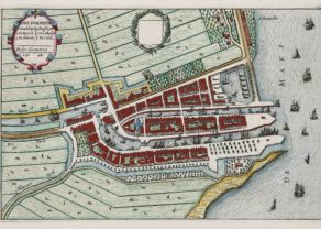
Delft – Delfi Batavorum vernacule Delft
by
Joan Blaeu
Detail
Date of first edition: 1649
Date of this map: 1652
Dimensions (not including margins): 37,5 x 49 cm
Dimensions including margins): 51 x 62,5 cm
Condition: Excellent. Lovely old colouring. Strong paper and wide margins. Centre fold as published.
Condition rating: A+
Verso: text in Latin
Map reference: Van der Krogt IV-2,1, 1018; Fauser #2936
From: Novum Ac Magnum Theatrum Urbium Belgicae Liberae Ac Foederatae (Town atlas). Amsterdam, J. Blaeu, 1649. Van der Krogt IV-2,1, 43:112: on verso “ijC”.
Unless otherwise specifically stated on this map page, we charge the following expedition costs in euro (unfortunatelly, gone up with Covid, but still too low in reality!):
– Benelux: 40 euro
– Rest of Europe: 60 euro
– Rest of the World: 100 euro
This item is sold
Related items
You may also be interested in:

Cuzco (Inca capital)
by
Giovanni Battista Ramusio
Price (without VAT, possibly to be added): €850,00 / $943,50 / £756,50
Rare first edition (block destroyed by fire)

Toledo (Castile) – Toletum
by
Georg Braun and Frans Hogenberg
Price (without VAT, possibly to be added): €1 500,00 / $1 665,00 / £1 335,00

Veere – Vere
by
Ludovico Guicciardini
Price (without VAT, possibly to be added): €420,00 / $466,20 / £373,80

Algiers – Algerii Saracenaorum Urbis Fortissimae…
by
Georg Braun and Frans Hogenberg
Price (without VAT, possibly to be added): €800,00 / $888,00 / £712,00
Blaeu’s Delft, a jewel to visit
Delft had long been an important city in the county of Holland: in 1400 only Dordrecht (8000 inhabitants) and Haarlem (7000) were larger than Dellft with 6500 inhabitants. In 1560 Amsterdam was the largest city of the county with 28,000 inhabitants, followed by Delft, Leiden and Haarlem each with about 14,000 inhabitants.
After King Philip II had declared William of Orange an outlaw on March 15, 1580, the latter was killed in the Prinsenhof by Frenchman Balthasar Gérard. He came out for being a refugee nobleman the name Francois Guyon. The facts date July 10, 1584. Gérard was captured and publicly executed on July 14, 1584.
On the market square one notices the Nieuwe Kerk (New Church) and the town hall; just left of them Oude Kerk (Old Church) opposite the Prinsenhof.
Many members of the Nassau family, starting with William of Orange and his son Maurice of Nassau to the princes Claus and Bernard and Queen Juliana are buried in a crypt under the Nieuwe Kerk. The crypt is not open to the public.
Bottom right runs the Schie, originally a small river but made into an canal and then running into the Overschie. The name “Delf” might indeed refer to the digging (delven) or excavating of the river. The Overschie then runs into the towns of Schiedam, Delfsfhaven (harbor of Delft) and Rotterdam, all on the Meuse, and now forming part of the port area.
The excavated city sewage (1616-1620; bottom right) was the object was of a famous painting of Vermeer, Gezicht op Delft (View of Delft) held by the Mauritshuis (Den Haag).
In 1654, so several years after the production this map, the whole northeastern city neighborhood was destroyed after an explosion of a secret underground storage of gunpowder. Carel Frabritius, painter and pupil of Rembrandt was among the victims.