
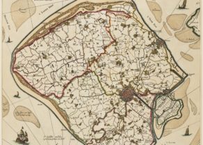
Zeeland
Top left a sea monster with Neptune, holding the weapons of Zeeland
Detail
Date of first edition: 1570
Date of this map: 1606-1612
Dimensions (not including margins): 33,5 x 46,5 cm
Condition: good. Sharp copper. Centre fold is as published. Original colouring. Wide margins, but here and there restored.
Condition rating: A/B
Verso: text in Latin with page signature 46
Map reference: Van den Broecke, 78.8; Blonk-van der Wijst (Zeeland), 2
From: Theatrum Orbis Terrarum
In stock
A success story
This map was very successful and published from 1570 to after 1612.
The map was continuously altered, since the waterfront changed rapidly. Ortelius published 9 states of Zeeland. This map is the 8th state of the map, published between 1606 and 1612. Changes in the 8th state included the insertion of four nameplaces in Zeeuws Vlaanderen: S. Philippe, Fort S. Jorge, Hasegat and Ysendyck.
Related items
-
[Untitled] Walcheren in Zeeland
by Nicolaes VisscherPrice (without VAT, possibly to be added): €1 600,00 / $1 776,00 / £1 424,00Visit Walcheren!
-

Veere – Vere
by Ludovico GuicciardiniPrice (without VAT, possibly to be added): €420,00 / $466,20 / £373,80 -
Middelburg – Middelburgum
by Joan BlaeuPrice (without VAT, possibly to be added): €900,00 / $999,00 / £801,00A jewel to visit
-
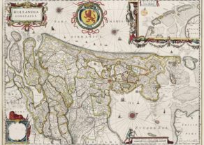
Holland – Hollandia Comitatus
by Willem and Joan BlaeuPrice (without VAT, possibly to be added): €1 350,00 / $1 498,50 / £1 201,50Orientated west to the top of the map. Inset of Frisian or Wadden islands
You may also be interested in:

Avignon
Papal city²

Jan Mayen – Insulae Johannis Mayen Cum universe situ Sinuum et Promontariorum
Rare Spanish edition

The Eastern Hemisphere – Hemisphaerium Orbis Antiqui
