
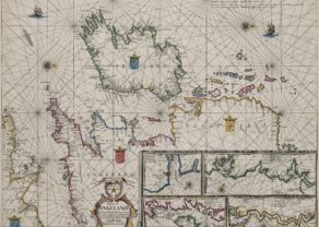
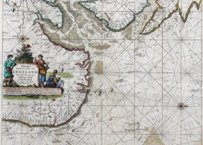
Thames estuary
by
Johannes van Keulen
Detail
Date of first edition: 1686
Date of this edition: 1686 or later
Dimensions (not including margins): 50 x 57,5 cm
Dimensions (including margins): 53,5 x 61 cm
Condition: Very good Mint. Sharp copper engraving printed on paper. Centre fold as published. Age-toned. Small old repair in margin top right at verso. Old outline colouring. Wide margins.
Condition rating: A
Verso: blank
Map reference: Koeman, Keu IV, 70
From: De Zee-atlas or De Nieuwe Groote Lichtende Zee-Fakkel
Price (without VAT, possibly to be added): €900,00 (FYI +/- $999,00 / £801,00)
Unless otherwise specifically stated on this map page, we charge the following expedition costs in euro (unfortunatelly, gone up with Covid, but still too low in reality!):
– Benelux: 40 euro
– Rest of Europe: 60 euro
– Rest of the World: 100 euro
In stock
Original title: Nieuwe paskaert van d’Oost Kust van Engeland van Dover tot Dunwich als mede de Teems off de Rivier van Londen
Inset map: Paskaertje van de Rivier van Londen van Gravesendt, en’t N. Blockhous tot Londen
Related items
You may also be interested in:

Asia Secunda pars Terrae in Forma Pegasi
by
Heinrich Bünting

Lucca
by
Georg Braun and Frans Hogenberg
Price (without VAT, possibly to be added): €700,00 / $777,00 / £623,00

China, Tartary and Japan
by
Lorenz Fries (after Martin Waldseemüller)
Price (without VAT, possibly to be added): €4 000,00 / $4 440,00 / £3 560,00
The first modern map of China printed in Europe

Luxembourg, Duchy
by
Abraham Ortelius
Price (without VAT, possibly to be added): €750,00 / $832,50 / £667,50