


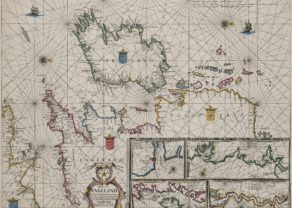
English coast, Hull to Yarnmouth
by
Johannes van Keulen
Charting at its best
Detail
Date of first edition: 1697 – 1709
Date of this map: 1697 – 1709
Dimensions (not including margins): 51,8 x 58,5
Dimensions (with margins): 53,5 x 60 cm
Condition: Good. Strong copper impression on paper and narrow margins. Slight age-toning and repair top right. Centrefold as published but now flattened.
Condition rating: A
Verso: blank
From: De Nieuwe Groote Lichtende Zee-Fakkel, 1697-1709, Chart No. 22, Amsterdam
Price (without VAT, possibly to be added): €750,00 (FYI +/- $832,50 / £667,50)
Unless otherwise specifically stated on this map page, we charge the following expedition costs in euro (unfortunatelly, gone up with Covid, but still too low in reality!):
– Benelux: 40 euro
– Rest of Europe: 60 euro
– Rest of the World: 100 euro
In stock
Related items
You may also be interested in:

Jan Mayen – Insulae Johannis Mayen Cum universe situ Sinuum et Promontariorum
by
Joan Blaeu, Johannes Janssonius
Rare Spanish edition

Edinburgh
by
Georg Braun and Frans Hogenberg
Price (without VAT, possibly to be added): €1 700,00 / $1 887,00 / £1 513,00

Achaia, Attica and Gulf of Corinth
by
Johannes Janssonius
Price (without VAT, possibly to be added): €450,00 / $499,50 / £400,50

Scotland – Nova Scotia
by
Willem and Joan Blaeu
Price (without VAT, possibly to be added): €1 000,00 / $1 110,00 / £890,00
A nice map of Scotland
Coast of England from Hull and Boston to Yarnmouth and Norwich
Full title: ‘Pas-caert Vande Zee-custen van Engeland Van Orfordnes tot een Flamborger Hooft’- with a cartouche at centre left with farmers herding and shearing sheep, and the impressum: ‘t’Amsterdam By Joannes van Keulen …
Typical van Keulen chart with many rhumb lines and indication of sandbanks, and water depth.
Center right a superb cartouche with three figures in rural setting.
Orientation: West.