


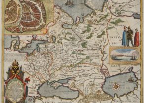
Moscou – Moscauw
Detail
Date of first edition: 1575
Date of this map: 1575
Dimensions (not including margins): 35,5 x 49 cm
Dimensions (including margins): 41,4 x 53,2 cm
Condition: Very good. Strong paper and wide margins. Verso discolouration due to earlier framing.
Condition rating: A; verso: B
Map reference: Van der Krogt 2862
From: Civitates Orbis Terrarum, … Part 2: De Praecipuis, Totius Universi Urbibus, Liber Secundus. Köln, Bertram Buchholz, 1597. Van der Krogt 4, 41:1-3, page 47
In stock
Moscou commented by Braun
“But because of its size the city has no proper end and also it has not been sufficiently fortified with walls, moats or ramparts, but the streets are closed with barriers at several places; when night falls, a strong guard is placed there, so that no one can pass through at night after a certain hour. […] The Moskva River flows around part of the city, and it is joined very close to the city by the Yauza, which, due to its high bank, can only rarely be waded through.”
TRANSLATION OF CARTOUCHE TEXT: Moscow, capital of the eponymous region, twice as large as Prague in Bohemia, has wooden buildings, many streets, but scattered, with wide spaces in between them. The Moskva irrigates the city.
Taschen on Moscou
Moscow is shown very schematically in a bird’s-eye view; between the groups of identical houses are e few people and some very simplified large buildings. In contradiction to the text, the city is surrounded by a wall. According to legend, Moscow was founded in 1147 by Yuri Dolgoruki; by the 15th century it had become a large city with decisive wordly and religious power. The symbol of wordly power is the Kremlin, which was constructed from 1485 to 1495 and extended in several stages up to 1530. In 1472, through the marriage of Ivan III with the Byzantine Princess Sophia Palaiologos, the niece of the last East Roman emperor, Moscow also became the centre of the Russian-Orthodox church. By 1600 the fast-growing city already had more than 100,000 inhabitants. On the right people can be seen taking sleigh rides on the Moskva, which is incongruous with the vegetation, and the foreground Russian soldiers, here called “Moscovites”, are depicted.
Related items
You may also be interested in:

Lisbon

San Adrian (Navarre) – La Sierra de Sant Adrian en Biscaia

China, Tartary and Japan
The first modern map of China printed in Europe

Kremlin
Moscow was founded in 1147 by Yuri Dolgoruki at the confluence of the wide and the narrow Neglinnaya Moskva (now largely underground flowing to the Kremlin). “Kremlin” means high city or fortified town. The principality of Moscow was expanding northward: around 1320 it took principality of Vladimir-Suzdal. In 1478 Grand Duke Ivan III (1440-1505, also known as Ivan the Great) subjugated the Republic of Novgorod and already in 1485 the Tver principality.
The Kremlin shown here, was built between 1485 and 1495. Notice the wooden houses. At the time of drafting of this map Moscow and Russia were at a turning point. In 1547 Grand Duke Ivan IVth (grandson of Ivan III) was crowned as the first Tsar. He will also be known as Ivan the Terrible). The territorial expansion was steady: between 1550 and 1700, each year an average area of 35,000 square kilometers (slightly more than the size of Belgium) were added.
Could the plain next to the right enclosure be today’s Red Square?
The figures on this sight are Muscovites and sleigh riders, coming from Rerum Moscoviticarum Commentarii by Sigismund von Herberstein in 1549. According to Braun Moscow was already twice as large as Prague; the city would have counted around 1600 already 100,000 inhabitants.