
Russia with Moscou (Blaeu after Gerritsz)
From the very rare and unfinished Spanish edition of the Atlas Maior
Detail
Date of first edition: 1634
Date of this edition: 1659-1672
Dimensions (not including margins): 42 x 54 cm
Condition: excellent. Sharp copper engraving printed on paper. Old coloured. Wide margins.
Condition rating: A+
Map reference: Van der Krogt 1800:2.2
From: Nuevo Atlas o Teatro del Mundo, unfinished Spanish edition of the Atlas Maior. Van der Krogt 2:641-2. Koeman I, BL 60A (pp. 271-291), cf. A. Berkhemer, ‘De Spaanse Atlas Mayor van Blaeu: nieuwe gegevens’, in Caert-Thresoor 16 (1997) 3, pp. 71-76, H. De la Fontaine Verwey, The ‘Spanish Blaeu,’ in Quaerendo 11 (1981), pp. 83-94.
In stock
Blaeu and Russia
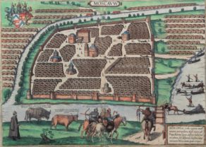
This map includes two insets: a plan of Moscow and a view of Archangel. The plan of Moscow is a reduced version of a Russian plan dating from approx. 1597-1599 and was probably copied by Fyodor Godunov as a school exercise. A note to the reader chiefly describes the fortifications of the city: “Gentle reader, here you see the sections of the walls of the city of Moscow divided into four, or rather the four fortifications of the walls, of which the innermost is called Kitaygorod and is also a city itself. Closest to this is the castle, or rather the palace, surrounded by walls, and called Kremlenagrad, which is encircled by two walls of stone, to which a few other materials have been added. The city, which continues to the east, north and west, is called Tsargorod, the city of the tsar: surrounded by walls of white stone but with earth added. The surrounding area outside is called Skorodum, with walls of wood but no earth; the part of it is situated on the other side of the Moskva River, however, is called Strelzka Slaboda, and soldiers live in the houses there, and the guard of the great lord the tsar and the grand duke, and other children of Mars.” The walls of Kitaygorod were built between 1534 and 1538. The nine-kilometer wall with 28 towers that surrounds Tsargrad, or Belgorod (white city), were built between 1583 and 1593. The outermost earthworks with a wooden wall was constructed in 1591. This part of the city was called Zemlyanoigorod (earthen city). In this earthen walls were 12 gates.
Related items
You may also be interested in:

Achaia, Attica and Gulf of Corinth

Antequera (Andalusia)

San Adrian (Navarre) – La Sierra de Sant Adrian en Biscaia

Gerritsz and Russia
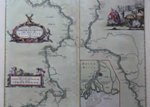
The full title of this map is: “Tabula Russiae ex autographo, quod delineandum curavit Foedor filius Tzaris Boris desums… – Domino regionum Iueriae Kartalinie et Groefiniae Tzari etc: dedicata ab Heselo Gerardo M.DC.XIIII”
A re-issue, by Willem Blaeu, of Hessel Gerritsz’ rare and influential map of Russia.Spanish text on verso, extending west to east from Emden to Aspachan and north to south from Langenos to Trapesus. This fine map was compiled from manuscripts brought back from Russia, by Isaac Massa to whom the large inset plan of Moscow is attributed.There is also a small view of Archangel. Russia’s only northern port until the founding of St Petersburg in 1700. Three figures in Russian dress stand above. The title is within a martial cartouche.
First issued 1613 and published by Blaeu after he acquired the plate following Gerritsz’s death in 1632. The top left corner has an inset plan of Moscow with a 17-point key.
The coat-of arms and the gun and sword carried by the person above the inset of Archangel heightened in gold.
The atlas Major was printed only in small numbers, the Spanish text edition is extremely rare. The Spanish edition was never completed. When fire destroyed the Blaeu printing house at the Gravenstraat in Amsterdam in 1672, the final volume was in the press and consequently lost.
The Spanish edition of the Atlas Maior
The Atlas Maior is the epitome of decades of achievement by the Blaeu family. Published in five languages (Latin, Dutch, French, German and Spanish) from 1662, it grew to eleven or twelve volumes in its most comprehensive editions, and was as Koeman observes a “costly atlas . . . Exclusively designed for those members of the patriciate who could command both the material and intellectual resources that were needed to buy and appreciate it”. Joan’s father, Willem Blaeu, commenced publication of his new world atlas, the Theatrum Orbis Terrarum, also referred to as the Atlas Novus, initially in two volumes, published in four languages. After succeeding his father, Joan Blaeu progressively expanded the Atlas Novus to six volumes by 1655, and this formed the first half the Atlas Maior.
The rare Spanish edition of the Atlas Maior occupies an extraordinary place within the Blaeu epic. In contrast to the editions in other languages, its volumes were printed serially over fifteen years, printed in more limited quantity, bore different titles, and were not numbered. The genesis of this project came with the decision to produce the Spanish Atlas Nuevo, with the volume relating to Scotland first published in 1657, and that on China the following year.
In 1659 the volumes relating to Northern Europe, Eastern Europe and England were produced, along with second editions of the two volumes already published. Even before Joan Blaeu had made preparations to publish the Atlas Maior in other languages, he decided to turn the extant volumes of the Atlas Nuevo into the first five volumes of the Atlas Mayor. The long process of production meant that there were variations in title and imprint, as well as the collation of specific volumes.
The volume on Spain was the last to be printed, before a fire which broke out in Blaeu’s Gravenstraat workshop on the night of 22-23 February, 1672. It destroyed many of the original copper plates and printed sheets for the Atlas Mayor, and led to production of the projected eleventh volume, relating to Asia, Africa and America, being abandoned.
The Atlas Mayor (the Spanish edition of the Atlas Maior) is the rarest edition of what De la Fontaine Verwey called “the greatest and finest atlas ever published”.