
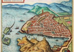
Lyon – Lugdunum
At the confluence of Rosne and Saone
Detail
Date of first edition: 1572
Date of this map: 1582
Dimensions (not including margins): 34 x 48 cm
Condition: Excellent. Strong image with lovely old original colours and wide margins. Centre fold as published.
Condition rating: A+
Verso: text in German
Map reference: Taschen, Br. Hog., p. 64; van der krogt IV-2,1, 2525
From: Civitates Orbis Terrarum, Liber Primus, van der Krogt, IV-1, p. 190; edition 1582: ‘seim… hat’
This item is sold
Description
TRANSLATION CARTOUCHE TEXT LEFT: Strabo writes that Lyons was in his day the second best-known city in Gaul and the most densely populated after Narbonne. And the city has by no means grown any smaller today, for its walls surround such a large area, including two hills and vineyards, that very few cities in France come before Lyons. There is a great influx of foreigners who have taken up residence here, so that they can buy and sell goods conveniently in every part of the world. The pleasantness of the location can be seen in the course of the rivers and in the fact that it lies almost at the centre of Europe. The rivers are the Rhône and the Arar (today called the Saône), which converge near Lyons and flow into the Ligurian Sea, which is very convenient for the import and export of goods.
COMMENTARY BY BRAUN (on verso): “Lyons has very beautiful houses and well-tended gardens. In wealth it exceeds all other cities in the whole of Romandy. The reason for this wealth is the rivers, because they lie near major cities. Since Lyons is situated in the middle of Europe and hence is called the heart of the Welschland, these rivers offer the best means of exporting and importing all interesting kinds of goods from the most lands in Europe.”
Lyons’s position between the Saône and the Rhône, so advantageous in terms of transportation, is impressively conveyed in this plan view from a steep bird’s-eye perspective. The city’s oldest surviving church, the Romanesque Benedictine abbey of Saint-Martin-d’Ainay, consecrated in 1107, is visible in the centre of the city, together with the part Romanesque, part Gothic cathedral of Saint-Jean. Through its close trade links with Italy, but also as a consequence of the Italian Wars (1494-1559), Lyons became a centre of humanism and printing in the late 15th and early 16th century. In the 16th century the city’s proximity to Geneva resulted in increased exposure to Protestant ideas, and in 1562-1563 Lyons was even taken by Protestants. In 1536 Francis I awarded Lyons the monopoly for weaving gold, silver and silk textiles and thereby fuelled the growth of the silk industry that from the 16th century onwards would make Lyons France’s first “industrial town”. More than half the population of Lyons earned their living from silk. Faience production also increased from 1512.
Related items
You may also be interested in:

Veere – Vere

Luxembourg, Duchy

Scotland – Nova Scotia
A nice map of Scotland

China, Tartary and Japan
The first modern map of China printed in Europe