


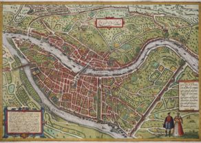
Paris – Lutetia
Paris s’éveille
Detail
Date of first edition: 1572
Date of this edition: 1574
Dimensions (not including margins): 34 x 48 cm
Dimensions (including margins): 38,7 x 51 cm
Condition: very good. Sharp copper engraving printed on paper. Original colouring. Top margin smaller than the rest. Professional repair at centre top.
Condition rating: A+
Map reference: Van der Krogt IV 2-2, 3298; Taschen, Br. Hog., p. 61.
From: Civitatis Urbis Terrarum (Liber primus. First published 1572, this edition 1574, Köln. Van der Krogt IV 2-2, 41:2-3, page 8
In stock
Paris commented by Braun
“Paris is the capital of the most highly productive Kingdom of France, on account of its incredible size, the nobility, merchants and burghers, its number of students and its notable buildings. The city that lies between the University and the main town is connected to the University by two bridges and to the town proper by three, lined on both sides with houses. On this spot Philip the Fair built a royal palace, containing a little chapel constructed with wonderful skill. Here also is a magnificent church dedicated to Our Lady, which is considered a wonder of the whole of France on account of its wonderfully beautiful form, size and artistically skilful pictures.”
TRANSLATION OF CARTOUCHE TEXT LEFT: Lutetia, commonly known as Paris, is the largest city in France and has the navigable Seine flowing around it. With the nobility, merchants, an excellent university, the stupendous church of Notre-Dame, the royal palace and other outstanding buildings, with a fair judiciary and most beautiful epitaphs, it is a most flourishing city.
CARTOUCHE RIGHT: Paris is truly a royal house / Of the god Apollo in his radiant splendour / Is like Cyrrea full of good minds / Vigorously it brings forth divers writings / Is like Chrysea abundant in metals / Almost like Greece flourishing in wisdom / The India of study and the Rome of poets / Athens, lastly, through famous scholars / Rosebush of the world, balsam of the firmament / Universal, the ornament of Sidon / Abundant in food and drink / Rich in lovely meadows and damp riverbanks / Fruitful in wine, mild for its citizens / Fertile in wheat and many other goods.
Original title: Lutetia vulgari Nomine Paris, Urbs Galliae Maxima, Sequana Navigabili Flumine Irrigatur…
Taschen on Paris
Paris is shown from a bird’s-eye perspective. In the 16th century, under Henry IV, the city was transformed into a splendid capital; in the present engraving, however, this process has not yet begun. The urban layout within the city walls is illustrated very clearly, as is the Seine flowing around the Île de la Cité with the Sainte-Chapelle, the palace chapel. During the reign of Philip IV (Philip the Fair) the Tour d’Argent and Tour de César gatetowers and the Tour de l’Horloge clock tower were built. The city numered some 200,000 inhabitants. Just beyond the city wall at the top of the picture is the large Fort la Bastille. On a fictive hill three people clad in typical contemporary dress are shown from an idealized viewpoint. In the first half of the 16th century, France copied the stiff Spanish fashions: hence the man wears a Spanish cape with a stand-up collar and epaulettes over a padded doublet and hose, while the ladies wear corsets and close-fitting ruffs.
This plan is copied from the “Premier Plan” from c. 1530, which Sabastien Münster also used in a smaller representation for his Cosmographia, 1569. All the 16th-century representations of Paris are attributed to the “Premier Plan”, which is supposed to have measured approximately 5 x 4 m and to have been made between 1523 and 1530. Two city gates that were built by Philip II, Augustus, in 1180 feature in the illustration, although they were demolished c. 1530.
Related items
-
Lyon – Lugdunum
by Georg Braun and Frans HogenbergAt the confluence of Rosne and Saone
-
Lille – Insula, Vulgo Lille, Belgice Riissel
by Joan BlaeuPrice (without VAT, possibly to be added): €650,00 / $721,50 / £578,50 -
Strasbourg – Argentoratum or Straszburg
by Georg Braun and Frans HogenbergSeat of the EU Parliament
-
Marseille
by Georg Braun and Frans HogenbergPrice (without VAT, possibly to be added): €700,00 / $777,00 / £623,00
You may also be interested in:

Lucca

Map of the Moon – Tabula Selenographica in qua Lunarium
The unique and famous first comparative chart of the Moon (with double competing nomenclature) from which the names of many lunar features have been derived.

The Eastern Hemisphere – Hemisphaerium Orbis Antiqui

Paris in the past
This most beautiful map of Paris appeared in the first edition of the Braun and Hogenberg atlas in 1572, but the drawing of the view goes back to at least 1529. Bottom center one recognizes a medieval castle, the old Louvre Castle built under King Philip II Augustus between 1190 and 1202. This castle, however, had already been demolished under King François I in 1529. Other landmarks are the Notre-Dame and the Sainte-Chapelle, both on the Île de la Cité, which formed the core of Roman Paris (Lutetia). Just behind this island lies the then still undeveloped Île Saint-Louis. In the top middle of this view thrones the Bastille Saint-Antoine, shown in its later structure built between 1370 and 1381. In the 16th century, the Bastille served as a weapons depot and reception space for King Francis I and later as a royal treasure trove for King Henry IV. Paris in this period was perhaps the largest European city with about 200,000 inhabitants in 1590 and even 400,000 in 1637.