

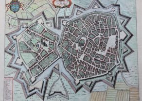
Valenciennes – Valentiana
by
Joan Blaeu
Detail
Date of first edition: 1649
Date of this map: 1649
Dimensions (not including margins): 51,5 x 41,5 cm
Dimensions (with margins): 63 x 53 cm
Condition: Very good: sharp copper engraving on strong paper and wide margins.
Condition rating: A+
Verso: text in Latin
From: Novum Ac Magnum Theatrum Urbium Belgicae (= “Stedeboeck”) Amsterdam, J. Blaeu, 1649. Koeman, Bl63
Price (without VAT, possibly to be added): €380,00 (FYI +/- $421,80 / £338,20)
Unless otherwise specifically stated on this map page, we charge the following expedition costs in euro (unfortunatelly, gone up with Covid, but still too low in reality!):
– Benelux: 40 euro
– Rest of Europe: 60 euro
– Rest of the World: 100 euro
In stock
Related items
-
Arras – Atrebatum, Gallis ARRAS Belgice ATRECHT dictu
by Joan BlaeuPrice (without VAT, possibly to be added): €370,00 / $410,70 / £329,30 -
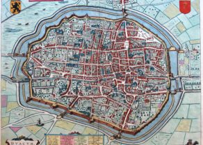
Lille – Insula, Vulgo Lille, Belgice Riissel
by Joan BlaeuPrice (without VAT, possibly to be added): €650,00 / $721,50 / £578,50 -
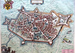
Cambrai – Cameracum vulgo Cambray
by Joan BlaeuPrice (without VAT, possibly to be added): €370,00 / $410,70 / £329,30 -
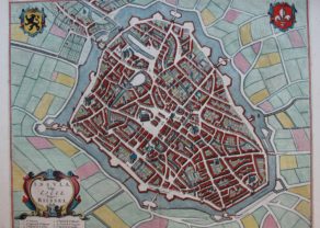
Douai – Dvacum vulgo Douay
by Johannes JanssoniusPrice (without VAT, possibly to be added): €370,00 / $410,70 / £329,30Rare map
You may also be interested in:

Lisbon
by
Georg Braun and Frans Hogenberg
Price (without VAT, possibly to be added): €1 300,00 / $1 443,00 / £1 157,00

Scotland – Nova Scotia
by
Willem and Joan Blaeu
Price (without VAT, possibly to be added): €1 000,00 / $1 110,00 / £890,00
A nice map of Scotland

China, Tartary and Japan
by
Lorenz Fries (after Martin Waldseemüller)
Price (without VAT, possibly to be added): €4 000,00 / $4 440,00 / £3 560,00
The first modern map of China printed in Europe

[Untitled] Japan
by
Benedetto Bordone
Price (without VAT, possibly to be added): €2 800,00 / $3 108,00 / £2 492,00
Very rare: oldest map of Japan, and … based on Polo’s description
In 1677, the armies of Louis XIV of France (this time led by Vauban[) captured the city and in 1678 the Treaties of Nijmegen gave the French control of Valenciennes (1678) and the surrounding southern part of Hainault, roughly cutting the former County in half. Since then it has been part of France.