")
")
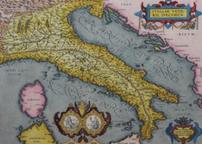
Italy, Austria and Dalmatia – Tabula Europae V
by
Sebastian Münster
Detail
Date of first edition: 1540
Date of this map: 1540
Dimensions (not including margins): 33,3 x 27 (bottom) cm
Dimensions (with margins): 39,5 x 31 cm
Condition: Very good woodcut engraving on strong paper and wide margins. Bottom centre fold old repaired. Original colouring.
Condition rating: A
Verso: text in Latin
Map references: Karrow, 58/79.
From: Geographia Universalis, Vetus et Nova, complectens Claidii Prolemaei Alexandrini enarrationis libros VIII. Basel, Heinrich Petri, 1540.
Price (without VAT, possibly to be added): €1 000,00 (FYI +/- $1 110,00 / £890,00)
Unless otherwise specifically stated on this map page, we charge the following expedition costs in euro (unfortunatelly, gone up with Covid, but still too low in reality!):
– Benelux: 40 euro
– Rest of Europe: 60 euro
– Rest of the World: 100 euro
In stock
Related items
You may also be interested in:

Avignon
by
Georg Braun and Frans Hogenberg
Papal city²

[Untitled] Japan
by
Benedetto Bordone
Price (without VAT, possibly to be added): €2 800,00 / $3 108,00 / £2 492,00
Very rare: oldest map of Japan, and … based on Polo’s description

Michiel de Ruyter, a super collection by Stoopendaal
by
Daniël Stoopendaal
Maybe the greatest admiral of all times

Algiers – Algerii Saracenaorum Urbis Fortissimae…
by
Georg Braun and Frans Hogenberg
Price (without VAT, possibly to be added): €800,00 / $888,00 / £712,00
Rare first edition and first state of woodcut of Italy, Austria and Dalmatia
This map is the first map of Münster of the region around Italy, based upon Claudius Ptolemy, as the region was then known.
This is the first edition, first state of Münster’s map: in the second state, the small device after “EUROPAE V”, is replaced by an identical device as before “TABULA”.
With remarkable accuracy Munster traced the mountains of the north and eastern sides of the Adriatic, the Dinaric Alps, which dominate the western region of the Balkans, but he did not depict the Appenines in Italy itself. Major cities are denoted throughout the map, with miniature architectural renderings to represent them. River systems and islands are depicted and named. A marvelous dolphin carries a cupid on its back. The map extends as far north as Germany and as far south as the toe of Italy and a portion of Sicily.
Münster’s Geographia (1st issued in 1540) and Cosmographia (1548) are the most important and widely copied geographical works of the middle part of the 16th Century and represented for most Europeans the first accessible imagery (maps and views) of the world.