


Alhama (Andalusia)
Detail
Date of first map: 1575
Date of this map: 1575
Dimensions (without margins): 34 x 46 cm
Dimensions (including margins): 41,5 x 52,5 cm
Condition: Very good copper engraving. Sharp printing. Centre fold as published. Wide margins. Small professional repair at back (bottom in margin).
Condition rating: A+
Verso: text in Latin
Map reference: Van der Krogt 4, 84, State 1; Taschen, Braun and Hogenberg, p.199.
From: Civitates Orbis Terrarum, Part 2: De Praecipuis, Totius Universi Urbibus, Liber Secundus. Köln, Gottfried von Kempen, 1593. (Van der Krogt 4, 41:1.2)
In stock
Alhama commented by Braun
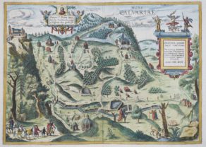
“Alhama is not the least of Spain’s cities and is seven miles away from the splendid city of Granada. […] The city and its surroundings have been richly endowed by nature: considering its fertile soil, high mountains, walleys and rivers, this place lacks nothing. And yet all these gifts are far surpassed by the warm baths that spring up there […]. These baths are considered, not unjustly, one of the most amazing wonders in the whole of Spain.”
Taschen on Alhama
The engraving shows a dramatic rocky landscape in front of the city, which is embedded in the Valley of the Marchan. In the foreground the road to Granada can be seen. The Spanish city of Alhama de Granada is still known for its baths today. It was the Romans who discovered the hot springs and built the first thermal bath in the town, which was known then as Artigi. In the 8th century the Moors conquered the Tolosan Kingdom of the Visigoths and gave Artigi the new name Alhama, derived from the Arabic word al-hamma meaning “hot water”. After the end of the Reconquista in the 15th century, Alhama de Granada became a popular destination of the Spanish nobility. Alhama is in the southwest of the province of Granada and is enclosed by the Alhama River. (Taschen)
Related items
-
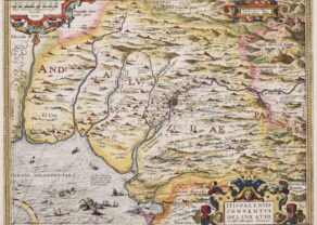
Andalusia – Andalicia, Hispalensis Conventus delineation
by Abraham OrteliusPrice (without VAT, possibly to be added): €600,00 / $666,00 / £534,00Diocese of Seville: the religious essence
-

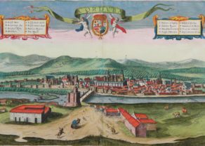
Antequera (Andalusia)
by Georg Braun and Frans HogenbergPrice (without VAT, possibly to be added): €475,00 / $527,25 / £422,75 -
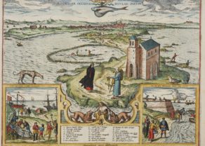
Cadiz – Gades ab occiduis insulae partibas
by Georg Braun and Frans Hogenberg -
Cordoba – Corduba
by Georg Braun and Frans HogenbergPrice (without VAT, possibly to be added): €1 200,00 / $1 332,00 / £1 068,00Idyllic view full of history
You may also be interested in:

Lisbon
Kalwarya Zebrzydowska with Mons Calvariae (Krakow)

China, Tartary and Japan
The first modern map of China printed in Europe

Alhama
A bird’s-eye view of the small town of Alhambra, southwest of Granada, drawn by George Hoefnagel in 1563 (mnentioned at bottom). The town is shown across a valley in a mountainous countryside.
Typically, local inhabitants are shown in the foreground, lending cultural interest to this interesting topographical image. The town derives its name from the Arabic word al-hamma meaning “hot water”.
There is clear evidence that the Romans used the hot springs located near the town. In the 8th century the Moors conquered the Tolosan Kingdom of the Visigoths and gave Artigi the new name Alhama. After the end of the Reconquista in the 15th century, Alhama de Granada became a popular destination of the Spanish nobility. Alhama is in the southwest of the province of Granada and is enclosed by the Alhama River.
The view shows a dramatic rocky landscape in front of the city, which is embedded in the Valley of the Marchan. In the foreground the road to Granada can be seen. The Spanish city of Alhama de Granada is still known for its baths today. It was the Romans who discovered the hot springs and built the first thermal bath in the town, which was known then as Artigi., derived from the Arabic word al-hamma meaning “hot water”. After the end of the Reconquista in the 15th century, Alhama de Granada became a popular destination of the Spanish nobility. Alhama is in the southwest of the province of Granada and is enclosed by the Alhama River.
The Civitates Orbis Terrarum
Being the greatest publication in its genre, the Civitates Orbis Terrarum, was compiled and written by George Braun, Canon of Cologne Cathedral. Braun gathered together vast amounts of information and draft plans to produce over 500 city views/maps published in six parts between 1572 and 1617.
Most of these engravings were made by Simon Novellanus and Frans Hogenberg, many after drawings by Joris Hoefnagel.