


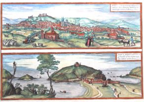
Cordoba – Corduba
Idyllic view full of history
Detail
Date of first edition: 1617
Date of this edition: ca. 1617
Dimensions (not including margins): 33,4 x 49,7 cm
Dimensions (including margins) 41,2 x 53 cm
Condition: Excellent. Sharp copper engraving printed on hard paper. Superb old colouring. Wide margins. Centre fold as published.
Condition rating: A+
Map reference: Van der Krogt 4, 941; Taschen, Br. Hog. p. 470
From: Civitatis Urbis Terrarum (VI: Theatri praecipuarum Totius Mundi Urbium Liber Sextus Anno MDCXVII), 1617. Van der Krogt 41:1-3
In stock
Cordoba commented by Braun
“This is a very noble and extremely interesting city. […] But in particular the soil on the northern side, where the mountains begin, is so fertile that it produces not only oil, wine, cherries, figs, peaches, plums, bitter oranges, lemons and similar delicious fruits, but also many beautiful wild trees grow on the highest peaks and precipitous rocks, as if out of the stone, especially of the kind that is called lotos in Latin, whose fruit is so sweet that anyone who has eaten of it can no longer resist the desire to eat more.”
Taschen on Cordoba
This slightly elevated view from the southeast shows the city before the backdrop of the Sierra de Cordoba. In the foreground the 14th-century Torre de la Calahorra (D) can be seen, behind which is the Roman bridge (H) that crosses the Quadalquivir and leads to the cathedral (A). Built in the 8th century as a mosque and enlarged in the 9th/10th centuries, it was converted into a Christian church after the Spanish recaptured the city. On the left is the Alcazar de los Reyes Cristianos (G), begun under Alfonso XI in 1328, the residence of the Spanish kings; from the end of the 16th century the Inquisition had its seat here. Once the capital of the wealthy Roman province of Baetica, Cordoba was conquered by the Moors in AD 711 and as the residence of the Umayyad Caliphate it was one of the biggest cities in the world at that time. In 1236 Cordoba became Christian again in the course of the Reconquista. (Taschen)
Related items
-

Lisbon
by Georg Braun and Frans HogenbergPrice (without VAT, possibly to be added): €1 300,00 / $1 443,00 / £1 157,00 -
Burgos and San Sebastian
by Georg Braun and Frans HogenbergPrice (without VAT, possibly to be added): €600,00 / $666,00 / £534,00 -
Toledo (Castile) – Toletum
by Georg Braun and Frans HogenbergPrice (without VAT, possibly to be added): €1 500,00 / $1 665,00 / £1 335,00


You may also be interested in:

Edinburgh
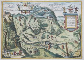
Kalwarya Zebrzydowska with Mons Calvariae (Krakow)

Map of the Moon – Tabula Selenographica in qua Lunarium
The unique and famous first comparative chart of the Moon (with double competing nomenclature) from which the names of many lunar features have been derived.
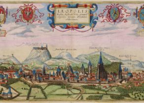
Lviv
Very rare map
Old Cordoba
“Karduba”, built along the river Guadalquivir, got its first known name of the Carthaginians. It was a contraction of Kart-Juba (city of Juba), named after a general who lost his life in the vicinity of the town, around 250 BC. Cordoba became the first Roman colony of the peninsula. The city was conquered by the Romans in 206 BC. After his coup Julius Caesar installed here the regional seat of government for the then called “Cordaba Hispania Ulterior”. Córdoba was captured in 711 by a Moorish army. In 716 it became a provincial capital, subordinate to the Caliphate of Damascus. The highlight of the city coincides with the proper “Caliphate of Cordoba” between 929 and 1031 that included most of Spain and Portugal, and in addition some areas in North Africa. This period is also regarded as the culmination of Islamic Spain. The most important building is the Mezquita (letter G), the Cathedral constructed in the middle of the mosque. Emir Abd Ar-Rahman I began in 785 with the construction of an impressive mosque (mezquita), with 23,000 m², the third largest of its kind in the world. The Islamic prayer house came to stand on the site of the early Christian Church of San Vincente. With the conquest of Cordoba in 1236, part of the Reconquista (Reconquest), the mosque was hence forward dedicated as a Catholic Cathedral. In its midst and starting from 1523 (and for the next 234 years to come) a great Gothic nave was constructed, with renaissance and baroque influences. The former minaret now serves as a Bell Tower.
Other visible legacies are the Roman bridge (letter H) and the Torre Calahorra (letter D). This engraving dates back to 1617 and was first published in the 6th and final part of the city atlas of Braun and Hogenberg.