


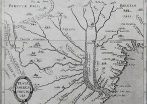
Hispaniola Insula
Full of history
Detail
Date of first edition: 1597
Date of this map: 1597
Dimensions of the map (not including margins): 23,1 x 28,3 cm
Dimensions (including margins): 28,5 x 36,2 cm
Condition: Very good. Sharp print. Centre fold as published. Wide margins.
Condition rating: A+
Verso: blank
Map reference: Van der Krogt III,B 9630:371, page 9 (top right)
From: Descriptionis Ptolemaicae Augmentum; Van der Krogt, IIIB, no specific atlas reference
This item is sold
Hispaniola
Hispaniola was known in cartographic circles long before Wytfliet. As early as 1528, Bordone drew the island, including the settlement of Isabella, followed by Ramusio (1534), Gastaldi (1548), Ruscelli (1561) and others. The island of Hispaniola (Haiti / Dominican Republic) will be forever linked to Columbus. On Christmas Day December 25, 1492, the vessel Santa Maria ran aground outside the current site of Cap Haitien, but the ship was lost. Columbus established the first Spanish settlement here, which he named after the date of Jesus’ birth, La Natividad, shown on the map as P. Nativitat on the north coast of modern-day Haiti. On his return the following year and after the dissolution of La Natividad, Columbus founded a second city, Isabella, further east in today’s Dominican Republic. Wytfliet gave ample commentary on Columbus’s travels to Hispaniola.
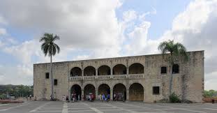
San. Domingo was founded by Bartolomeo Columbus, Christopher’s younger brother, and it became the oldest permanently inhabited European settlement in America in 1496. It also became the first seat of Spanish colonial rule in the New World. In 1509 Diego Columbus (son of Christopher) succeeded his father as “Governor of the Indies”. He had his house built there, the El Alcázar de Colón, which still stands in Santo Domingo:
The importance of the city is also evident from the expeditions that led to Cortés’ (1485-1547) conquest of Mexico and Balboa’s foray into Panama from San. Domingo were executed. The further history of this island remains intriguing. In 1586 Francis Drake captured the city and returned it for ransom.
Drake’s invasion and his sack of Hispaniola weakened Spanish rule over the island so that the Spanish left all of the island except the capital for the next 50 years. The island was left to the whims of pirates. In 1655, Oliver Cromwell made an unsuccessful attempt to reclaim the city of Santo Domingo. He then withdrew and took Jamaica in its place. Under the Treaty of Rijswijk of 1697, Spain formally ceded the western third of the island (now Haiti) to France. From 1930 to 1961, the city was temporarily called Santo Domingo “Ciudad Trujillo” when Rafael Trujillo, dictator of the Dominican Republic, named the capital after himself. Haiti is now the poorest country in the Western Hemisphere. Finally, the Turks and Caicos Islands can be seen in the northwest corner of Hispaniola (to the left of the map).
Related items
You may also be interested in:

Lucca

Algiers – Algerii Saracenaorum Urbis Fortissimae…

[Untitled] Japan
Very rare: oldest map of Japan, and … based on Polo’s description

Jan Mayen – Insulae Johannis Mayen Cum universe situ Sinuum et Promontariorum
Rare Spanish edition
Cornelius Wytfliet (? – 1597)
Cornelius Wytfliet was a geographer from Leuven. After graduating Licentiate in Laws from the University of Leuven, Wytfliet moved to Brussels and became secretary to the Council of Brabant.
In 1597 he published the first atlas of America: the Descriptionis Ptolemaicae Augmentum (Augmentation to Ptolemy’s description). He named his work an augmentation to Ptolemy’s Geography because it covers the Americas, a part of the world unknown to Ptolemy. However, there is no other connection between the works of Ptolemy and Van Wytfliet. Dedicated to Philip III of Spain it is a history of the New World to date, recording its discovery, natural history, etc. It provides a history of exploration and the voyages of Christopher Columbus (1492-1502), John Cabot (1497-98), Sebastian Cabot (1526-28), Francisco Pizarro (1527-35), Giovanni de Verazzano (1524), Jacques Cartier (1540-42), and Martin Frobisher (1576-78). Most of Van Wytfliet’s maps are the first or among the earliest of specific regions of North and South America.
For the book, Wytfliet had engraved nineteen maps, one of the world and eighteen regional maps of the Americas. The book was an immediate success and ran to several editions.
Two editions of the Descriptionis Ptolemaicae were published et Leuven in 1597 and 1598. In 1603 appeared the first Douai edition with later editions with French text. The last edition was published in Arnhem in 1615.