


North America (USA, Canada, Greenland) – America Settentrionale
A moment frozen in time
Detail
Date of first edition: 1832
Date of this map: 1832
Dimensions (without margins): 30,5 x 45 cm
Condition: Excellent engraving on hard paper. Superb colouring and wide margins.
Condition rating: A+
Verso: blank
In stock
America Settentrionale
A PLACE FROZEN IN TIME: NORTH AMERICA, ANNO 1832
The Louisiana Purchase, whereby the young republic bought an enormous chunk of the North American continent was already consummated a long time ago. In 1803 Napoleon sold to some 2,140,000 km2 (an area roughly the size of Greenland or Saudi Arabia) to the Jefferson administration. Note that during the French revolution he had been the US representative in France!
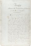
This region stretched from the Mississippi River to the Rocky Mountains; so the purchase doubled the size of the United States. In fact, Spain had just recently ceded ownership of the Louisiana territory in 1800 to the more predominant France (see picture of the original first page of the treaty)… and the US administration did not feel conformable with an important French presence next to its doors… Hence… the purchase. And this would not be the last expansion of the new nation….
The map crystallizes geography in time (the subtitle refers to the famous Lewis and Clark expedition of 1804-1806):
- the USA is colored in pink; However, the entire Oregon Territory was only incorporated as a ‘state’ into the USA in 1859.
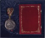
- the yellow western part “Parte del Mexico”: At the end of the Mexican–American War (1846–1848) Mexico (which had only become an independent state in 1821) ceded all its territory north of the Rio Grande to the USA (see also picture of the original cover of the exchange copy of the treaty of Guadalupe Hidalgo of February 2, 1848).
- the light green colored Alaska only became American after the purchase under the Andrew Johnson administration in 1867.
- Canada remained British until its independence in 1931/1982. The name “Canada” likely comes from the Huron-Iroquois word “kanata,” meaning “village” or “settlement.”
- light yellow Greenland, Danish territory. Notice the confusion on the map whereby the island is still connected to northern Canadian territory.
Of course, the international border between the USA and Canada underwent several changes.
You may also be interested in:

Michiel de Ruyter, a super collection by Stoopendaal
Maybe the greatest admiral of all times

Cuzco (Inca capital)
Rare first edition (block destroyed by fire)

Algiers – Algerii Saracenaorum Urbis Fortissimae…

Jan Mayen – Insulae Johannis Mayen Cum universe situ Sinuum et Promontariorum
Rare Spanish edition
Comte de las Casas
The mapmaker was Emmanuel-Augustin-Dieudonné-Joseph, comte de Las Cases (21 June 1766 – 15 May 1842). He was a French atlas-maker and author, famous for an admiring book about Napoleon, Le Mémorial de Sainte-Hélène.