


Strait of Magellan – Magellanica D
Detail
Date of first edition: 1644-1655
Date of this map: not exactly determinable (between 1644 and 1680)
Dimensions copper plate (without margins): 41,3 x 52,75 cm
Dimensions (including margins): 46,5 x 59,2 cm
Condition: Very good. On strong paper with wide margins. Centre fold as published. Superb colouring. Slight age-toning.
Condition rating: A+
Verso: blank
Map reference: Van der Krogt I, 9950:1C.2
From: in eight publications by Janssonius between 1644 and 1680; see Van der Krogt I, page 720
In stock
Magellanica with Le Maire
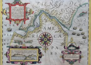
From 1630, the house of Hondius published a new map of the Strait, containing new data. The map is indebted to the journey of Jacob le Maire and Willem Cornelisz Schouten. Jacob’s father, Isaac, had founded the Austraelsche Compagnie through his belief in the great South Country with the aim of claiming exclusive trade for these (virtual) southern areas. This map shows the places already known above. Hondius also mentions “Portofamine” in the Strait of Magellan. It concerns the Spanish attempted settlement of “Rey don Felipe” with three hundred men in March 1584 under Pedro Sarmiento de Gamboa to block access to the strait to other nations, especially England. When the third world circumnavigation with Thomas Cavendish passed in 1587, it turned out that all Spanish settlers had died.
Cavendish renamed the place Port Famine, which was later translated into Spanish as Puerto Hambre or Puerto del Hambre. On the empty space of Tierra del Fuego, Janssonius mentions that the image of the Strait of Magellan is based on information from Barent Iansz Potgieter from Munster. Let’s go back to Jacob le Maire and his contributions, which can be admired directly on the map. So, we notice:
• The Fretum le Maire of course immortalized its name. He proved that at least Tierra del Fuego was not part of the Terra Australis, the unknown Southland. And Staten Lant? There is no definite answer yet!
• C. de Horen, named after one of his two ships. The island of Cape Horn was then temporarily considered the southernmost point of South America.
• The islands of Terhalten, Ewoudt and Barnevelt are still called that way.
• The bays Greyhond (still known as Bahia Greyhond) and Schapenham in the Nassausche Voerd.
The discovery of the passage under the Tierra del Fuego (known as the settlement of Ushuaia) was a major maritime breakthrough that ensured faster and safer passage between the two oceans. In the very south of the map are the I. De Diego Ramires. These islands were first spotted on February 12, 1619, during Garcia de Nodal’s expedition, and named after the expedition’s “cosmographer”, Diego Ramírez de Arellano. At the moment they are home to the most southern (Chilean) inhabited American point, as the Argentines had to leave the more southern Thule in 1982. In 1624 the so-called Nassausche fleet passed through under the command of Jacques l’Hermite. His ship journalist, Johannes van Walbeeck, will include some places on the south coast of Tierra del Fuego, which are shown on this map.
Janssonius
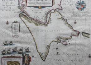
This is one of the most elaborately decorated maps to focus on the tip of South America with the Strait of Magellan and Le Maire Strait. The coastlines are depicted as very mountainous, while the interior is completely without detail. Instead the region is filled with a hunting scene, exotic birds including rheas and penguins, and a quaint scene of village life. The map is further adorned with a pair of compass roses, three sailing ships, and four beautiful cartouches. The key to the map is in a strapwork cartouche held aloft by putti, while another cartouche at right dedicates the map to Gualtherus de Raet, judge at the Court of Holland. The cartouches arrayed across the bottom of the map present a unique distance scale in checkerboard format and the title with a tribe of Fuegian natives, penguins and shells. This is the second state with a dedication to Gualtherus de Raet.
The checkerboard in the lower left corner is not evidence of local sophistication, but rather represents a variable scale. This enabled sailors to counteract the increasingly exaggerated distances caused in high latitudes using Mercator’s projection. (Campbell)
Title: Tabula Magellanica qua Tierrae del Fuego, cum Celeberrimis Fretis a F. Magellano et I. Le Maire Detectis Novissima et Accuratissima Descriptio Exhibetur
Related items
You may also be interested in:

Asia Secunda pars Terrae in Forma Pegasi

San Adrian (Navarre) – La Sierra de Sant Adrian en Biscaia

Jan Mayen – Insulae Johannis Mayen Cum universe situ Sinuum et Promontariorum
Rare Spanish edition

Collective purchase: an eccentric proposal
Have a look at our blog page. (just click here).
We have placed a lengthy and detailed historical and geographical study on the three main (Dutch) maps of the Strait of Magellan and Cape Horn. Here we mingle history and geography, continuing to the present! You find them under the name Strait of Magellan – Magellanica A, B and C.
A unique offer: We now sell this special set of four maps (A to D) at the discount price of 4.500 euro (transport costs and possible VAT excluded).