


Kodungallor (Cranganore)
by
François Valentyn
Detail
Date of first edition: 1724-2726
Date of this map: 1724-1726
Dimensions (not including margins): 29,5 x 37 cm
Dimensions (including margins): 32,4 x 38,2 cm
Condition: Excellent. Centre fold as published. Smaller margins, except bottom
Condition rating: A+
Verso: blank
From: “Oud en nieuw Oost-Indiën, vervattende een naaukeurige en uitvoerige verhandelinge van Nederlands mogentheyd in die gewesten, benevens eene wydluftige beschryvige der Moluccos … en alle de eylanden onder dezelve landbestieringen behoorende; het Nederlands comptoir op Suratte, en de levens der Groote Mogols”
Price (without VAT, possibly to be added): €300,00 (FYI +/- $333,00 / £267,00)
Unless otherwise specifically stated on this map page, we charge the following expedition costs in euro (unfortunatelly, gone up with Covid, but still too low in reality!):
– Benelux: 40 euro
– Rest of Europe: 60 euro
– Rest of the World: 100 euro
In stock
Related items
You may also be interested in:

The Eastern Hemisphere – Hemisphaerium Orbis Antiqui
by
Johannes Janssonius, Andreas Cellarius
Price (without VAT, possibly to be added): €2 800,00 / $3 108,00 / £2 492,00

Lisbon
by
Georg Braun and Frans Hogenberg
Price (without VAT, possibly to be added): €1 300,00 / $1 443,00 / £1 157,00

Bristol – Brightstowe, Vulgo; Quondam Venta, Florentissimum
by
Georg Braun and Frans Hogenberg
Price (without VAT, possibly to be added): €900,00 / $999,00 / £801,00

Edinburgh
by
Georg Braun and Frans Hogenberg
Price (without VAT, possibly to be added): €1 700,00 / $1 887,00 / £1 513,00
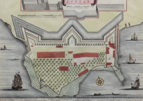
VOC at Cranganoor
Cranganoor (now Kodungallur or Kottapuram): from 1662 to 1770 possessed by the VOC. On the Malabar coast the VOC temporarily held posts at Kochi, Quilon, Pallippuram, Cranganoor Cannanur. The local rulers recognizedcertain rights by contract.
After the Dutch conquered Cranganoor on the Portuguese in 1662, they presented it to the zamorin (king) of Calicut as thanks for his assistance to the VOC in the further conquest of the Malabar Coast. But in 1666 the VOC started the restoration of the Portuguese fortress and they manned it with a garrison of fifty men. In fact, this Cranganoor always remained a purely military fortress to protect the important trading post in Cochin.
In the middle of the view one sees the cross-section of the fortification.
Full title: Grond Teekening van den Fortresse Cranganoor