


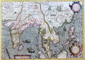
Kollam – Coylan
by
François Valentyn
Detail
Date of first edition: 1724-1726
Date of this map: 1724-1726
Dimensions (not including margins): 29 x 37 cm
Dimensions (including margins): 32,5 x 37,5 cm
Condition: Excellent. Centre fold as published. Smaller margins left and right.
Condition rating: A+
Verso: strenghetend
From: “Oud en nieuw Oost-Indiën, vervattende een naaukeurige en uitvoerige verhandelinge van Nederlands mogentheyd in die gewesten, benevens eene wydluftige beschryvige der Moluccos … en alle de eylanden onder dezelve landbestieringen behoorende; het Nederlands comptoir op Suratte, en de levens der Groote Mogols
Price (without VAT, possibly to be added): €275,00 (FYI +/- $305,25 / £244,75)
Unless otherwise specifically stated on this map page, we charge the following expedition costs in euro (unfortunatelly, gone up with Covid, but still too low in reality!):
– Benelux: 40 euro
– Rest of Europe: 60 euro
– Rest of the World: 100 euro
In stock
Related items
You may also be interested in:

San Adrian (Navarre) – La Sierra de Sant Adrian en Biscaia
by
Georg Braun and Frans Hogenberg
Price (without VAT, possibly to be added): €700,00 / $777,00 / £623,00

Bristol – Brightstowe, Vulgo; Quondam Venta, Florentissimum
by
Georg Braun and Frans Hogenberg
Price (without VAT, possibly to be added): €900,00 / $999,00 / £801,00

Antequera (Andalusia)
by
Georg Braun and Frans Hogenberg
Price (without VAT, possibly to be added): €475,00 / $527,25 / £422,75

Michiel de Ruyter, a super collection by Stoopendaal
by
Daniël Stoopendaal
Maybe the greatest admiral of all times
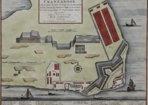
VOC at Kollam
Coylan (Quilon; now Kollam). In December 1658 Rijckloff van Goens, later gouvernor-general of the VOC led an army of 1,200 men led by Rijckloff of Goens, to capture Kolloam from the Portuguese. The local queen was agreed that the Portuguese possessions were ceded to the VOC against payment of certain rights From 1661 annd only for a period of two years it remained the (main) trade settlement for the VOC, until this function was taken over by Cochin. Kollam was especially important for the Dutch trade in pepper and pearls.
Full title: De Grond Tekening van den Fortresse Coylan