
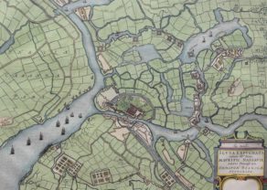
Geertruidenberg (siege in 1593)
by
Joan Blaeu
Detail
Date of first edition: 1649
Date of this map: 1649
Dimensions (not including margins): 45 x 57 cm
Condition: Very good. Strong paper and wide margins. Centre fold as published. Original colouring.
Condition rating: A+
Verso: text in Latin
Map references: Van der Krogt 4, 1460
From: Novum Ac Magnum Theatrum Urbinum Belgicae (Stedeboeck)
Price (without VAT, possibly to be added): €900,00 (FYI +/- $999,00 / £801,00)
Unless otherwise specifically stated on this map page, we charge the following expedition costs in euro (unfortunatelly, gone up with Covid, but still too low in reality!):
– Benelux: 40 euro
– Rest of Europe: 60 euro
– Rest of the World: 100 euro
In stock
Related items
-

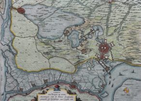
Sluis (siege of 1604)
by Joan BlaeuPrice (without VAT, possibly to be added): €575,00 / $638,25 / £511,75 -
Bergen op Zoom (siege in 1622)
by Claes Janszoon Visscher, Johannes JanssoniusPrice (without VAT, possibly to be added): €450,00 / $499,50 / £400,50 -
Fossa Eugeniana
by Willem and Joan BlaeuPrice (without VAT, possibly to be added): €400,00 / $444,00 / £356,00A cartographic curiosity
-
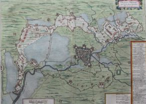
Breda (siege in 1624-1625)
by Joan BlaeuPrice (without VAT, possibly to be added): €500,00 / $555,00 / £445,00
You may also be interested in:

Avignon
by
Georg Braun and Frans Hogenberg
Papal city²

Asia Secunda pars Terrae in Forma Pegasi
by
Heinrich Bünting

China, Tartary and Japan
by
Lorenz Fries (after Martin Waldseemüller)
Price (without VAT, possibly to be added): €4 000,00 / $4 440,00 / £3 560,00
The first modern map of China printed in Europe

[Untitled] Japan
by
Benedetto Bordone
Price (without VAT, possibly to be added): €2 800,00 / $3 108,00 / £2 492,00
Very rare: oldest map of Japan, and … based on Polo’s description
Geertruidenberg: the siege of 1593
The Siege of Geertruidenberg was a siege of the city of Geertruidenberg that took place between 27 March and 24 June 1593 during the Eighty Years’ War. Anglo-Dutch troops under the commands of Maurits of Nassau and Francis Vere laid siege to the Spanish garrisoned city. The siege was unique in that the besiegers used a hundred ships, forming a semicircle in a chain on the Mass River to form a bloackade. A Spanish relief force under the command of the Count of Mansverld was attempted in May but this was defeated and he was later forced to withdraw. Three Governors of the city were killed – after the last fatality and as a result of the failed relief, the Spanish surrendered the city on 24 June 1593. The victory earned Maurits much fame and had thus become a steadfast strategist in the art of war
Title: Obsidio St Geertruydenbergae…