


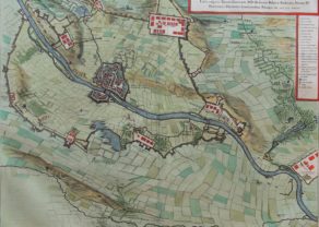
Sluis (siege of 1604)
Detail
Date of first edition: 1649
Date of this map: 1649 or 1652
Dimensions (not including margins): 38,8 x 49,8 cm
Dimensions (including margins): 50 x 60,3 cm
Condition: Excellent. Sharp engraving on strong paper. Centre fold as published. Attractive discrete original coloring. Wide margins.
Condition rating: A+
Verso: text in Latin
Map reference: Van der Krogt IV, 4026; Fauser, 13086
From: Novum Ac Magnum Theatrum Urbium Belgicae Regiae. Amsterdam, J. Blaeu, 1652; Van der Krogt IV, 43:111 (1649) or 43:113 (1652)
In stock
The siege of Sluis
Ostend had already fallen into Spanish hands.
The siege of Sluis (1604) or battle of the Oostburg line was a series of military actions that took place during the Eighty Years’ War from 19 May to 19 August 1604. A States (and English) army under Prince Maurice of Orange and Horace Vere respectively crossed the Scheldt estuary and advanced on land taking Cadzand, Aardenburg, and Ijzendijke in the Spanish Netherlands. This soon led to the culmination of the siege of the Spanish-held inland port of Sluis.
Tough fighting included the defeat of a Spanish relief force under Amrogio Spinola and Luis de Velasco.
Related items
-
Maastricht (siege in 1632)
by Joan BlaeuPrice (without VAT, possibly to be added): €800,00 / $888,00 / £712,00 -
Bergen op Zoom (siege in 1622)
by Claes Janszoon Visscher, Johannes JanssoniusPrice (without VAT, possibly to be added): €450,00 / $499,50 / £400,50 -
Zantvliet
by Claes Janszoon Visscher, Johannes JanssoniusPrice (without VAT, possibly to be added): €1 100,00 / $1 221,00 / £979,00Rare top war map
-
Breda (siege in 1624-1625)
by Joan BlaeuPrice (without VAT, possibly to be added): €500,00 / $555,00 / £445,00
You may also be interested in:

Algiers – Algerii Saracenaorum Urbis Fortissimae…

Edinburgh

Toledo (Castile) – Toletum
