


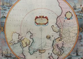
North Pole – Regiones Sub Polo Arctico
Detail
Date of first edition: 1642
Date of this map: 1644 – 1655 (Joan Blaeu)
Dimensions (without margins): 41 x 53 cm
Dimensions (including margins): 50,7 x 59,7 cm
Condition: Good copper engraving. Strong paper and wide margins.
Condition rating: A
Verso: text in Latin
Map reference: Van der Krogt 2, 0020:2.2
From: Theatrum Orbis Terrarum van der Krogt 2:202-3
In stock
Blaeu and the North Pole
This important prototype map of the Arctic incorporates new information from the explorations of Capt. Thomas James with the bay named for him labeled here James his Bay. The Arctic coast of Russia provides information from Willem Barentsz’ voyage, and Spitsbergen is shown according the Danish expedition of James Hall. Rhumb lines radiate from the North Pole, and a large title cartouche, with two figures and numerous wind heads, conveniently hides the northwest coast of America. The map is further decorated with several compass roses, ships, and an additional cartouche that features men in parkas, a polar bear, and foxes. Dedication to Guilielmo Backer de Corneliis.
Related items
You may also be interested in:

The Eastern Hemisphere – Hemisphaerium Orbis Antiqui

Lucca

Avignon
Papal city²
