


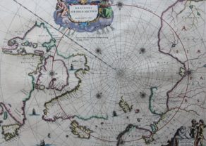
Poli Arctici – Azimuth Projection
The world from “above”
Detail
Date of first edition: 1636
Date of this edition: 1636 or 1638
Dimensions (not including margins): 34,5 x 59,5 cm
Dimensions (including margins): 47,8 x 55,3 cm
Condition: Very good and sharp copper engraving printed on hard paper. Old coloured. Centre fold as published. Wide margins. General light age-toning. Verso shows old repair, not recognizable on recto.
Condition rating: A
Verso: text in German
Map reference: Van der Krogt, I, 0020:1B
From: Appendix or Newer Atlas, Van der Krogt I, 1:324 or I, 1:421/2
Note: this item is exclusively offered with catalogue of Exhibition “The Dutch color the World”, organised at the Mercatormuseum in 2018.
In stock
The Azimuth Projection
The Mercator projection is not useful for a so-called polar projection. For the North Pole projection, the North Pole is projected perpendicularly from the South Pole and then any point on a flat sheet (placed on the North Pole) (the so-called azimuthal projection). Thus, all meridians become lines departing from the North Pole and the parallels (or latitudes) become concentric circles centered on the North Pole. When Jodocus Hondius purchases the copper plates from Mercator’s legacy, including his North Pole map from 1595, he will continue to use this “archaic” design (where the water disappears into the North Pole!) Until 1634. Not until 1636 did Henricus Hondius publish a new Poli Arctici with significant changes: no imaginative imagination, but a restriction to the representation of verified knowledge, so neither an evocation of four islands, but a body of water.
This leads to, among other things, the Canadian side of the North Pole being left open and Greenland and Nova Zembla not being completed. The imaginary Fryslandt is also omitted (for a discussion see V.5.2). The sources for this map are mainly English, including Henry Briggs and Thomas James. The Hudson Bay is faithfully depicted, thanks to the former. James, on the other hand, thought that Baffin was indeed an island. The bay, south of Hudson Bay, was named after him. Finally, note the Dutch nomenclature for many locations in Labrador, Greenland and Iceland. Oceanus Deucaledonius was the name for the North Atlantic Ocean. All corners are embellished with views of whaling. The copper plate later passed into the hands of Frederik de Wit and was printed until 1715.
The Azimuth North Pole projection is incorporated in the flag of the UN:

Related items
You may also be interested in:

Toledo (Castile) – Toletum

Portrait Abraham Ortelius, by Galle

Edinburgh

Burden on the Poli Arctici map
“With the many advances in knowledge of the Artic waters in the first third of the century the Gerard Mercator map of the North Pole, 1595, had become obsolete. In recognition of the large role taken by the English in pursuit of the North West Passage, Hondius introduced a new polar map for the English edition of his atlas, 1636. …
Hondius drew upon the cartography of Henry Briggs, 1625, for the outline of Hudson Bay, and supplemented it with the knowledge of the west coast from Thomas’ map, 1633. He does correctly, however, make an assumption that Baffin Island is an island. Like many other cartographers before him he is confused by the very early English voyages depicting M Forbishers Streate in Greenland. Similar to the AMERICA SEPTENTRIONALIS of the same year, he incorporates a second cartouche which is left blank. Along the Atlantic coast of Labrador we find for the first time much Dutch nomenclature, reflecting their increased whaling activities in these waters. It is also interesting to note that virtually all of the earlier imaginary islands in the North Atlantic are now omitted.”