


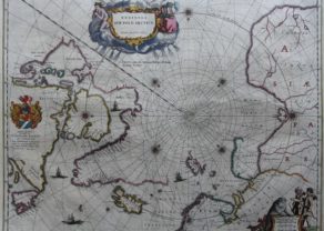
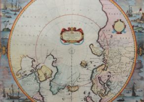
North Pole
by
Joan and Cornelis Blaeu, Willem Blaeu
Detail
Date of first edition: 1640
Date of this map: 1649
Dimensions (without margins): 53 x 41,5 cm
Dimensions (including margins): 56,5 x 48 cm
Condition: Good copper engraving. Centre fold as published, but at bottom (mainly in margins) old repair. Strong paper and wide margins. Small tear at left margin and slightly aged-toned.
Condition rating: A/B
Verso: text in Latin
Map reference: van der Krogt 0020:2.1
From: Appendix, Joan and Cornelis Blaeu. Van der Krogt 2:10A
Price (without VAT, possibly to be added): €1 200,00 (FYI +/- $1 332,00 / £1 068,00)
Unless otherwise specifically stated on this map page, we charge the following expedition costs in euro (unfortunatelly, gone up with Covid, but still too low in reality!):
– Benelux: 40 euro
– Rest of Europe: 60 euro
– Rest of the World: 100 euro
In stock
Related items
You may also be interested in:

Lisbon
by
Georg Braun and Frans Hogenberg
Price (without VAT, possibly to be added): €1 300,00 / $1 443,00 / £1 157,00

Portrait Abraham Ortelius, by Galle
by
Abraham Ortelius, Philip Galle
Price (without VAT, possibly to be added): €800,00 / $888,00 / £712,00

Bristol – Brightstowe, Vulgo; Quondam Venta, Florentissimum
by
Georg Braun and Frans Hogenberg
Price (without VAT, possibly to be added): €900,00 / $999,00 / £801,00

Antequera (Andalusia)
by
Georg Braun and Frans Hogenberg
Price (without VAT, possibly to be added): €475,00 / $527,25 / £422,75
Blaeu and the North Pole
Beautiful North Polar map, with several wonderful cartouches and decorative coat of arms. Wonderful detail, both real and imaginary, throughout the map. At the time this map was the most up-to-date map of the North Pole region available. To the left we see the discoveries of captain Thomas James of Bristol along the southern and western shores of the Hudson Bay during his expedition of 1631/32 (with, among others, “James his Bay”). Spitsbergen is drawn as it was known after the Danish expeditions of 1605-1607.