


Novalya Zemlya – Nova Zembla
Detail
Date of first edition: 1662
Date of this map: 1664
Dimensions of the map (not including margins): 38 x 49,5 cm
Dimensions (including margins): 50,5 x 64,4 cm
Condition: Very good. Centre fold as published. Wide margins.
Condition rating: A+
Verso: text in Dutch, with beautiful engraving of a walrus
Map reference: Van der Krogt 2, 1270:2
From: Grooten Atlas; Van der Krogt2:621, page D 5a
In stock
A story of Barentsz, van Heemskerck and Nova Zembla
Novgorod merchants had known Nova Zembla since the eleventh or twelfth century. For Western Europe, Nova Zemlya was an accidental sixteenth-century “discovery” in the search for a northeastern passage for Asian spices. The first known Western visitor was Hugh Willoughby in 1553. The “rediscovery of Nova Zembla”, however, is linked to the person of Willem Barentsz. Little is known about the life of Willem Barentsz. He was a merchant and scientist. Initially he sailed on Spain and the Mediterranean. Three times he attempted to find the northeasterly passage (the first of which twice with Jan Huygen van Linschoten, who described both voyages in 1601 in his Voyagie, or ship-vaert van by Noorden om langes).
In 1596 Barentsz left for the north for the third time, again with the sailor Jacob van Heemskerck. This time Barentsz did not sail eastwards from Scandinavia, but northwards.
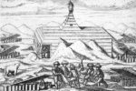
He discovered an island that he called Veere Island (present-day Bear Island, halfway between the North Cape and Spitsbergen) and further north an island that he called “the New Land” (modern Spitsbergen). Back on Bear Island, the expedition was split up. The other ship of this expedition, under Jan Corneliszoon Rijp, tried to find a passage between Spitsbergen and Greenland. Barentsz investigated the waters between Spitsbergen and Nova Zembla. He first managed to round the northern tip of Nova Zembla, but then got stuck in the pack ice. Out of necessity, the winter was spent in a self-built house, Het Behouden Huys (6 by 10 meters), in which the expedition team then spent the next ten months.
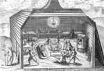
The following summer, an extra sloop was built so that the seventeen surviving crew members could return to civilization. Barentsz died a week after the departure. His resting place was never found. His men did return to Kola, where they were wonderfully picked up by their former fellow traveler Rijp. What a fluke! Gerrit de Veer, one of the survivors and ship journalist of this third voyage, made a detailed travelogue.
Blaeu is primarily obliged to borrow Barentsz’s own map from 1598. Joan Blaeu’s map, with many Dutch topographical names, shows Loms Bay (as mentioned by De Veer), the shipwreck at Het Behouden Huys and the return by sloop the following spring. The Norwegian whaler Elling Carlsen found the remains of Het Behouden Huys in 1871 and brought some of its objects with him. These are now in the possession of the Rijksmuseum. It was not until 1932 that the Russian icebreaker Sibirakov succeeded for the first time in sailing along the north side of Novaya Zemlya to Asia.
You may also be interested in:

Achaia, Attica and Gulf of Corinth

[Untitled] Japan
Very rare: oldest map of Japan, and … based on Polo’s description

Bristol – Brightstowe, Vulgo; Quondam Venta, Florentissimum
