


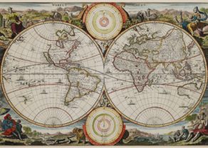
World – Orbis Terrarum Tabula Recens Emendata et in Lucem Edita
by
Nicolaes Visscher
First state world map, with California depicted as a peninsula.
Detail
Date of first edition: 1663
Date of this map: 1665 (also first state)
Dimensions (not including margins): 47,3 x 31 cm
Dimensions (with margins): 50 x 33,8 cm
Condition: Very good. Old colour. Strong print and clear image. Professional repairs to some minor fold separations
Condition rating: A+
Verso: text in Dutch
Map references: Shirley # 431; Portman & Augusteijn # 118
From: Bijbel
Price (without VAT, possibly to be added): €2 500,00 (FYI +/- $2 775,00 / £2 225,00)
Unless otherwise specifically stated on this map page, we charge the following expedition costs in euro (unfortunatelly, gone up with Covid, but still too low in reality!):
– Benelux: 40 euro
– Rest of Europe: 60 euro
– Rest of the World: 100 euro
In stock
Related items
You may also be interested in:

Chester – Cestria vulgo Chester, Angliae Civitas
by
Georg Braun and Frans Hogenberg
Price (without VAT, possibly to be added): €900,00 / $999,00 / £801,00

Toledo (Castile) – Toletum
by
Georg Braun and Frans Hogenberg
Price (without VAT, possibly to be added): €1 500,00 / $1 665,00 / £1 335,00

Avignon
by
Georg Braun and Frans Hogenberg
Papal city²

Achaia, Attica and Gulf of Corinth
by
Johannes Janssonius
Price (without VAT, possibly to be added): €450,00 / $499,50 / £400,50
The 17th century world in all its glory
The Dutch protestant republic produced many bibles. These were illustrated with scenes from the Old and New Testaments. This is the second world map (1663; the first one dates 1656) created by N. Visscher, meant as an addition in his bible Orbis Terrarum Tabula Recens Emendata et in Lucem Edita (published by Elsevier).
This superb double hemisphere world map is surrounded by engravings including allegorical representations of the continents (Europe, Asia, Africa and America) as well as native inhabitants and wildlife. Visscher’s decorations were so popular several other cartographers copied them. Two diagrams depicting the Ptolemaic and Copernican theories of the solar system appear within the cusps of the hemispheres. The northwest coast of North America is greatly exaggerated with the fictional El Streto d’Anian, while California is shown as a peninsula. In the Pacific, Western Australia, Van Diemens Landt, and a bit of New Zealand are also noted. This is the first state. Dutch text on verso.
Dutch text on the verso
Note that: