

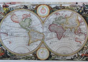
World – Werelt Caert
by
Daniël Stoopendaal
World map, with California depicted as an island. After a world-map by Nicolaas Visscher.
Detail
Date of first edition: 1665 (Visscher)
Date of this map: 1710 (Stoopendaal)
Dimensions (not including margins): 30,5 x 45 cm
Dimensions (including margins): 32 x 47,5 cm
Condition: Very good. Old colour. Strong print and clear image. Small tears on the centrefold are invisibly restored. Margins bottom and top narrow (3-10 mm.). Three folds as published. Verso: sings of previous framing
Condition rating: A+
Verso: text in Dutch
Price (without VAT, possibly to be added): €1 700,00 (FYI +/- $1 887,00 / £1 513,00)
Unless otherwise specifically stated on this map page, we charge the following expedition costs in euro (unfortunatelly, gone up with Covid, but still too low in reality!):
– Benelux: 40 euro
– Rest of Europe: 60 euro
– Rest of the World: 100 euro
In stock
Related items
You may also be interested in:

Chester – Cestria vulgo Chester, Angliae Civitas
by
Georg Braun and Frans Hogenberg
Price (without VAT, possibly to be added): €900,00 / $999,00 / £801,00

China, Tartary and Japan
by
Lorenz Fries (after Martin Waldseemüller)
Price (without VAT, possibly to be added): €4 000,00 / $4 440,00 / £3 560,00
The first modern map of China printed in Europe

Algiers – Algerii Saracenaorum Urbis Fortissimae…
by
Georg Braun and Frans Hogenberg
Price (without VAT, possibly to be added): €800,00 / $888,00 / £712,00

Cuzco (Inca capital)
by
Giovanni Battista Ramusio
Price (without VAT, possibly to be added): €850,00 / $943,50 / £756,50
Rare first edition (block destroyed by fire)
The 17th century World in all its Glory
The Dutch protestant republic produced many bibles. These were illustrated with scenes from the Old and New Testaments. This is the second world map (1663; the first one dates 1656) created by N. Visscher, meant as an addition in his bible Orbis Terrarum Tabula Recens Emendata et in Lucem Edita (published by Elsevier).
This superb double hemisphere world map is surrounded by engravings including allegorical representations of the continents (Europe, Asia, Africa and America) as well as native inhabitants and wildlife. Two diagrams depicting the Ptolemaic and Copernican theories of the solar system appear in the middle.
The northwest coast of North America is greatly exaggerated with the fictional El Streto d’Anian. Due to exploratory problems (Davis, Frobisher, Hudson, Cavendish) Visscher struggled with the northwestern passage. California is shown as a peninsula (where Wytfliet in 1597 projected a peninsula). Surprisingly, the map also displays the Great Wall of China!! In the Pacific, Western Australia (or Hollandia Nova) starts getting into shape. South of it Visscher shows a glimpse of Van Diemen’s Land, the name originally given to Tasmania. One notices also the east coast of New Zealand (in the Western hemisphere). Antarctica is completely absent. This is the second state (first map dates 1656)with Visscher’s grant of privilege noted under the title.
Daniël Stopendaal (1672- 1726) was a Dutch engraver, living in Amsterdam. He published this reprint in 1710. Wereld Caert, first edition 1663 N. Visscher – this edition +/- 1710 D. Stoopendaal.
On the original Visscher map California was correctly shown as a peninsula.