


Kent – Kent with her Cities and Earles Described and Observed
by
John Speed
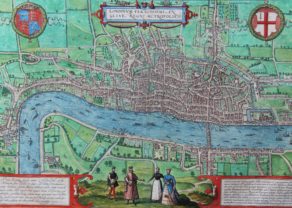
With insets of the cities of Canterbury and Rochester
Detail
Date of first edition: 1612
Date of this edition: 1612-1676
Dimensions (not including margins): 34 x 49 cm
Condition: very good. Sharp copper engraving printed on hard paper. Superb colouring. General slight age-toning. Few minor repairs at edges
Condition rating: A
From: Theatre of the Empire of Great Britaine, 1612
Price (without VAT, possibly to be added): €1 200,00 (FYI +/- $1 332,00 / £1 068,00)
Unless otherwise specifically stated on this map page, we charge the following expedition costs in euro (unfortunatelly, gone up with Covid, but still too low in reality!):
– Benelux: 40 euro
– Rest of Europe: 60 euro
– Rest of the World: 100 euro
In stock
Related items
You may also be interested in:

Chester – Cestria vulgo Chester, Angliae Civitas
by
Georg Braun and Frans Hogenberg
Price (without VAT, possibly to be added): €900,00 / $999,00 / £801,00

Asia Secunda pars Terrae in Forma Pegasi
by
Heinrich Bünting

Map of the Moon – Tabula Selenographica in qua Lunarium
by
Johann Gabriel Doppelmayr
Price (without VAT, possibly to be added): €3 500,00 / $3 885,00 / £3 115,00
The unique and famous first comparative chart of the Moon (with double competing nomenclature) from which the names of many lunar features have been derived.

Edinburgh
by
Georg Braun and Frans Hogenberg
Price (without VAT, possibly to be added): €1 700,00 / $1 887,00 / £1 513,00
Speed’s Kent: Gateway to Europe
John Speed mentions that Kent counts 2 cities, 27 castles and 32 market places. Its geographical location offered then and now enormous trade opportunities. However, it served as well as a fortress against possible foreign invasions. The Confederation of the “Cinque Ports” (in its Norman French) was established for military defense purposes. It included: New Romney, Hythe, Dover and Sandwich (all in Kent) and Hastings (in Sussex). The special administrative and judicial powers of this Confederation were finally eroded by the Great Reform Act of 1832.
At the very top left of the map London is just recognizable. At the top Speed placed the coat of arms of the “hundreds” (a hundred is a county division). In the bottom corners he shows insets of the two cities of Kent: Canterbury with its cathedral and Rochester with its Norman Castle (see picture below).
Speed remarks of Canterbury of Thomas Becket’s tomb “that for glory, wealth and superstitious worship equalized the pyramids of Egypt.”
When William the Conqueror defeated the Saxon troops of king Harold in 1066 at Hastings (see the war scene at the bottom), he decided to built a series of powerful castles to protect his new realm. In the southeast Norman strongholds were constructed in Canterbury, Dover, and Rochester). All three of them are open to visitors.
On Speed’s atlas
The atlas was completed in 1612; the maps are notable for the decorative elements included, evidence of Speed’s interest in antiquities and most have inset town-plans, the first series of printed town-plans of the British Isles, and were issued with descriptive English text printed on the verso. In the hands of different publishers, there were numerous editions to 1676 with text.