


Paulus’ Travels – Peregrinationis Divi Pauli Typus Chorographicus
With two key scenes of the life of Saint Paul
Detail
Date of first edition: 1579
Date of this map: 1598
Dimensions (not including margins): 35 x 50,5 cm
Dimensions (including margins): 49 x 60,5 cm
Condition: Very good. Sharp copper engraving printed on very strong paper. Very wide margins. Possibly original colouring.
Condition rating: A+
Verso: text in French
Map reference: Van der Krogt 0850H:31; Van den Broecke 181
From: Theatrum Orbis Terrarum; Van der Krogt 31:351, page 117.
In stock
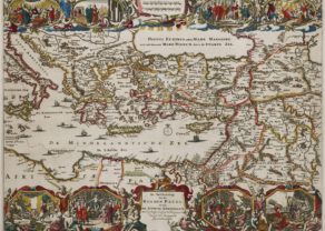
Travels of Paul
A gorgeous Ortelius map of the travels of St. Paul the Apostle through the Mediterranean, extending west to Italy and east to the Euphrates, including parts of the Red Sea and the Black Sea. First published by Ortelius in Antwerp in 1579. Signed and dated in bottom left corner.
Two ornate vignette scenes from the St. Paul’s travels are illustrated and coloured with unusual detail:
- The vignette at top left depicts Saul being struck down from his horse by divine rays;
- While to the right, Paul and his companions are miraculously guided ashore from the shipwreck that stranded him on Malta.
Several sailing ships and sea monsters in the Mediterranean. At the bottom, a quote from “2 Corinthians, 5”.
Related items
You may also be interested in:

Chester – Cestria vulgo Chester, Angliae Civitas

Asia Secunda pars Terrae in Forma Pegasi

Chart of the Gulf of Finland
